Towns
Pringle, South Dakota
A mile south of Pringle, on the route the George S. Mickelson Trail follows today, a mine and kiln once turned out lime for mortar and for improving soil, by the account of a South Dakota Game, Fish and Parks marker at the town's trailhead. Pringle, South Dakota, had 109 people in the 2020 census. It lies in Custer County, in the Southern Hills, on the southwest edge of the old crystalline rock at the heart of the Black Hills. The town was once called Point of Rocks, became a stop on the Burlington's line between Edgemont and Deadwood, and now sits on a long-distance trail, in the country between Jewel Cave and Wind Cave.
What Rock Does Pringle Stand On?
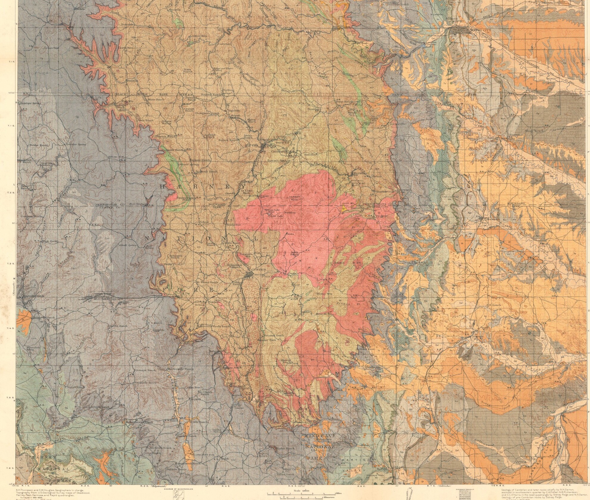
Pringle stands at the outer edge of the crystalline core, where a thin band of sandstone, the first layer of rock laid over the core, begins. The core, the innermost of the Black Hills' four rings of rock (see How the Black Hills Formed), is granite and metamorphic rock, changed by heat and pressure, about 1.7 billion to 2.5 billion years old (The Granite Core). On the geologic map in a 2002 U.S. Geological Survey study of the area's water, the core's rock runs right up to the town, and the limestone of the next ring begins just to its west and southwest.
That sandstone is the Deadwood Formation. In 1925 N.H. Darton and Sidney Paige of the U.S. Geological Survey dated it to the Late Cambrian and found it laid on a fairly smooth surface cut across the old schist and granite. Near Pringle, they reported, it is red-brown and fairly hard, 50 feet thick, with many fossils. Higher in the stack come the limestones that build the Limestone Plateau, the second ring and the rock that holds both caves near town (The Limestone Plateau and the Caves). Limestone was worked close by. Besides the kiln a mile south, the trailhead marker says, a siding 5 miles south of town served several quarries, where limestone was cut, and kilns that burned it into lime.
Point of Rocks, Lime and the Railroad
Before it was Pringle, the place went by Point of Rocks, a name both the Game, Fish and Parks marker and the State Archives' list of South Dakota towns record. A 2003 study for the National Park Service says the town grew up around a stage station of that name on the road between Cheyenne and Custer, and later took the name of a family among its first settlers. People there ranched as well as logged and mined in the early years, the study adds. The marker stands in the trailhead pavilion just north of Main and Railway streets, and one of its photographs shows an Army camp at Point of Rocks in the mid-1870s. In those years the Black Hills lay inside the Great Sioux Reservation that the 1868 Fort Laramie Treaty set apart for the tribes, and the Hills were later taken from the tribes without the consent the treaty required (The 1876 War and the Taking of the Hills).
The Chicago, Burlington and Quincy began its line north from Edgemont on May 15, 1890, and reached Deadwood on January 24, 1891; some 1,000 workers built the 114-mile line in 255 days, a Mickelson Trail sign that once stood at Deadwood recorded (see Stagecoaches and Railroads). By 1901 Pringle was a stop on the line, as a Burlington timetable from that year, reproduced on the trailhead marker, shows. The siding to the south, called Loring Siding, gave trains a short side track where one could pull aside off the main line.
The same marker gives mining and lumbering as the small town's trades, though it names no mine or mill (logging in the Hills is told on Logging the Ponderosa). A second marker, which the Pringle community set up at Main and Railway streets, records that the town's fire department bought a 40-gallon soda-and-acid extinguisher from Kadoka's fire department in 1936 for $75.
Trains last ran between Edgemont and Custer on October 29, 1986, when Burlington Northern stopped service on that stretch, the Deadwood sign recorded. The George S. Mickelson Trail now passes through town on a former rail line, 109 miles from Edgemont to Deadwood. On the Game, Fish and Parks trail guide, Pringle's trailhead sits at milepost 32.1 and 4,884 feet, and the Harbach Park trailhead in Custer, a town of 1,919 in 2020, at milepost 44.5. South of Pringle comes the longest gap between stops on the whole trail, 11.4 miles to the Lein Quarry trail stop.
Between Jewel Cave and Wind Cave
Pringle lies between the two long caves of the Southern Hills, with Jewel Cave to the northwest and Wind Cave to the southeast. By the Park Service's directions, Jewel Cave National Monument is about 13 miles west of Custer on US 16, and Wind Cave National Park about 20 miles south of Custer off US 385, its visitor center 11 miles north of Hot Springs. Both caves formed mainly in the same Mississippian limestone, the Park Service's geodiversity atlas says.
For the Lakota, Wind Cave is the passage through which the people came up into this world. The Park Service shares an Oglala telling of that emergence, from the Cheyenne Creek community on the Pine Ridge Reservation, that Wilmer Mesteth, a tribal historian and spiritual leader, passed to Sina Bear Eagle; the agency adds that each band and family may tell the story its own way (see Sacred Sites: Bear Butte, Devils Tower and Wind Cave).
Beyond the park to the south lies Hot Springs, with 3,395 people in 2020. South along the trail the ground keeps falling. Edgemont, at milepost 0 and 3,454 feet, is the trail's low end, about 1,400 feet below the Pringle trailhead.
Connected
- The Southern HillsThe warmer, drier end of the Hills, which holds Pringle and its neighbors.
- The Limestone Plateau and the CavesThe limestone ring above Pringle's sandstone, and the two caves in it.
- The Granite Core: Black Elk Peak and the NeedlesThe ancient core, whose rock reaches the edge of town.
- Wind Cave National ParkThe breathing cave and its prairie, southeast of town.
- Jewel Cave National MonumentThe crystal-lined cave northwest of town, west of Custer on US 16.
- The George S. Mickelson TrailThe rail-line trail through town, with its trailhead at milepost 32.1.
- Stagecoaches and RailroadsHow the Burlington built its line from Edgemont to Deadwood.
- The 1876 War and the Taking of the HillsHow the treaty land around Point of Rocks was taken from the tribes.
Sources
- Point of Rocks (marker text). South Dakota Game, Fish and Parks, in the Pringle trailhead pavilion of the Mickelson Trail; transcribed by the Historical Marker Database, 2026.
- 40 Gallon Soda and Acid Chemical Extinguisher (marker text). The Pringle Community, at Main and Railway streets, Pringle; transcribed by the Historical Marker Database, 2026.
- Track or Trail: Sweat Equity Played a Role (sign text). George S. Mickelson Trail, formerly at the Deadwood trailhead; transcribed by the Historical Marker Database.
- Central Black Hills Folio, South Dakota (Geologic Atlas Folio 219), by N.H. Darton and Sidney Paige. U.S. Geological Survey, 1925.
- Hydrology of the Black Hills Area, South Dakota (Water-Resources Investigations Report 02-4094), by Daniel G. Driscoll, Janet M. Carter, Joyce E. Williamson and Larry D. Putnam; figure 14, distribution of hydrogeologic units. U.S. Geological Survey, 2002.
- SD Towns. South Dakota State Historical Society, State Archives, 2010.
- The Home of the Bison: An Ethnographic and Ethnohistorical Study of Traditional Cultural Affiliations to Wind Cave National Park, p. 142. Patricia C. Albers and others, University of Minnesota for the National Park Service, 2003.
- George S Mickelson Trail (trail guide map with elevation profile). South Dakota Game, Fish and Parks, 2026.
- Directions. National Park Service, Jewel Cave National Monument.
- Directions. National Park Service, Wind Cave National Park.
- NPS Geodiversity Atlas: Wind Cave National Park. National Park Service.
- The Lakota Emergence Story, as told by Wilmer Mesteth and retold by Sina Bear Eagle. National Park Service, Wind Cave National Park, 2024.
- Fort Laramie Treaty (1868). National Archives, Milestone Documents.
- TIGERweb: 2020 Census incorporated places. U.S. Census Bureau.
Last reviewed: