Towns
Sturgis, South Dakota
The soldiers named the place before anyone had platted it, and the name was no compliment. In the summer of 1878, traders pitched their tents near the Army's new camp by Bear Butte, soldiers who visited tended to come back with empty pockets, and the troops called the place Scooptown. When a townsite was laid out beside the new post that August, the traders moved in, nickname and all. That town is Sturgis, the seat of Meade County, with 7,020 people in the 2020 census. It lies in the Red Valley at the eastern edge of the Northern Hills and has lived on an Army post, on cattle, on a veterans hospital and, since 1938, on a motorcycle rally each August.
Red Ground Inside the Hogback
Sturgis is a Red Valley town. The Red Valley is the lowland of soft red shale and siltstone, the Spearfish Formation, that rings the Hills just inside the Hogback, their outer ridge of hard sandstone. Around town, a flat-topped layer of gravel called the Sturgis terrace caps the red rock on both sides of Interstate 90, a South Dakota Geological Survey road log notes.
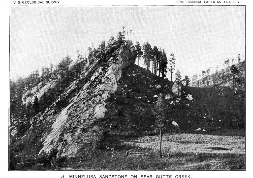
Bear Butte Creek comes out of the Hills down Boulder Canyon, and not all of it arrives. N.H. Darton of the U.S. Geological Survey reported in 1909 that, a few miles upstream of town, the creek lost itself in the Minnelusa sandstone. Part of the flow surfaced again near Sturgis, and the lower creek, down to the Belle Fourche River, usually carried water the year round. East of town the creek has cut a gap through the Hogback. Gold-rush trails from Bismarck, Fort Pierre and Sidney, Nebraska, came together there, a state historical marker on Highway 34 says, and Fort Meade went up beside the gap, just east of the ridge, at a spot the road log calls strategic.
That layout shapes what a visitor sees. From the interstate at Sturgis, drivers can pick out Bear Butte past the sandstone crest of the Hogback, the road log notes. To the west, Highway 14A climbs Boulder Canyon toward Deadwood. Travelers on the old toll road up the creek named the canyon for the big limestone boulders lying in its bed.
Fort Meade and Scooptown
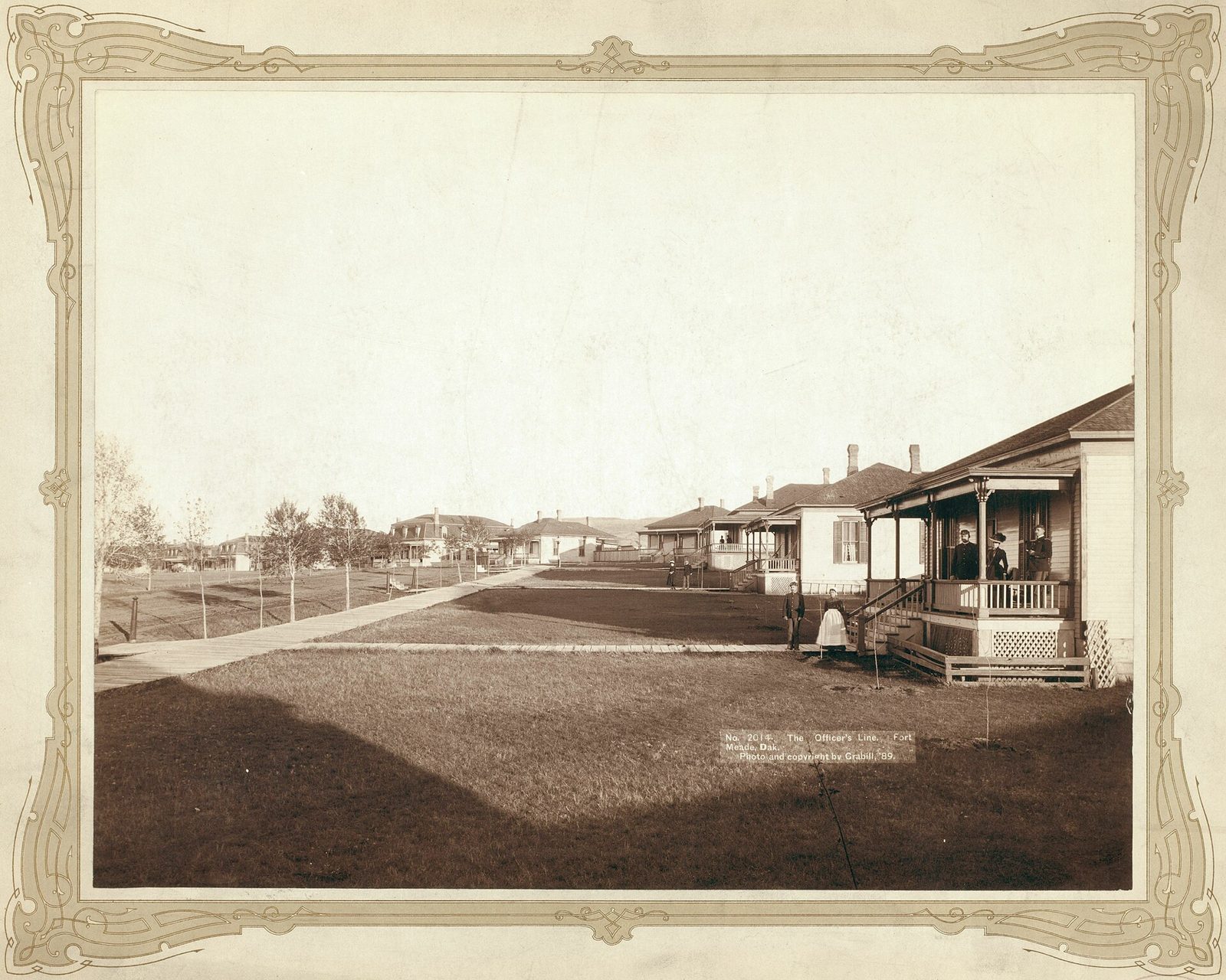
The Army came to stay in 1878. On July 1, troops set up Camp J.G. Sturgis near Bear Butte, named for Lt. James G. Sturgis, killed on June 25, 1876, at the Battle of the Little Bighorn, which the Lakota call the Battle of the Greasy Grass. The 7th Cavalry's commander, Col. Samuel D. Sturgis, arrived on July 18, a state historical marker on Highway 79 records. In late August the troops moved to Camp Ruhlen. Around the turn of 1879 it was renamed Fort Meade, for the Union general George G. Meade.
The Army placed the post there, its 1973 National Register nomination says, to control the Lakota and protect the mining district of the Hills, which the 1877 Act had taken from the tribes the year before without the consent the 1868 treaty required.
The town followed. Maj. Jeremiah Wilcox laid out Sturgis City near the new post on August 16, 1878, according to a marker at Junction Avenue and Harmon Street. A 1954 state marker puts the first Scooptown at a store a mile west of the Bear Butte camp, where soldiers tended to get "scooped," or cleaned out. The name, it says, clung to Sturgis for a time.
Sources split on the town's namesake. The marker in town names the colonel, Samuel D. Sturgis. Britannica and the 2010 road log name the lieutenant the 1878 camp honored, who was the colonel's son, as a National Park Service photograph record from the Little Bighorn battlefield notes. A 2023 Census Bureau story credits father and son together.
Sturgis was incorporated in 1888, Britannica says. When Meade County was split off from Lawrence County in 1889, Sturgis became its seat, and for want of a courthouse the county leased space upstairs in city hall at $1 a year.
Did the National Anthem Start at Fort Meade?
Not first, and not alone. A 1976 state marker on the old parade ground, by the hospital, says the song's road to becoming the national anthem began there in 1892. That year Col. Caleb Carlton of the 8th Cavalry, the post commander, settled on "The Star-Spangled Banner" at his wife's suggestion and required it at the evening retreat ceremony and as the last piece at parades and concerts. Writing in 1914, in words the marker quotes, Carlton recalled taking the custom to the Secretary of War, Daniel Lamont, some time afterward, and believed an order for every Army post followed a few months after that. The fort's National Register nomination repeats the chain with a cautious "purportedly." SAH Archipedia, the Society of Architectural Historians' online encyclopedia, goes further: by its account, no military body played the song before Fort Meade did.
The record says otherwise. In 1889, three years before Carlton's order, the Navy's secretary made the song the music for raising the flag each morning, and the Smithsonian's National Museum of American History counts that as the earliest official move toward an anthem. The marker also dates the anthem law to 1914; the act of Congress making the song the national anthem is dated March 3, 1931. Fort Meade's custom may have helped spread the song through the Army, as Carlton thought. It was one step of several.
Supplies, Cattle and a Veterans Hospital
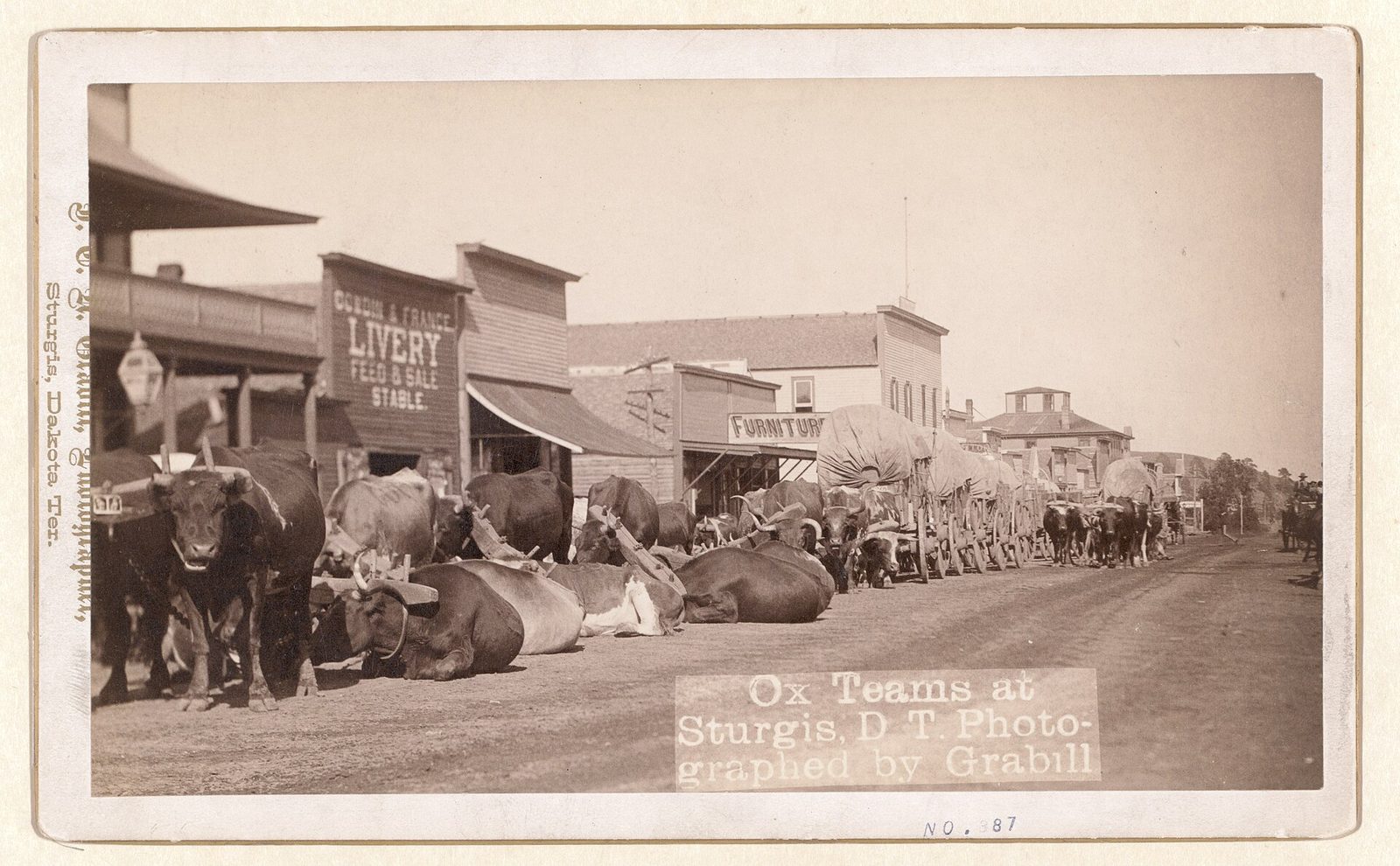
For its first decades Sturgis was a supply town. Its merchants did business with the mining camps, the fort and the cattle outfits, and the town prospered on all three, says the 1975 National Register nomination for the Sturgis Historic Commercial District. The district's nine buildings at Main Street and Junction Avenue, most from the late 1890s and six of them faced with stone cut nearby, held hardware stores, groceries, saloons and newspaper offices.
The Army kept Fort Meade for 66 years. The 7th Cavalry had its headquarters there early on, and the 4th Cavalry between the world wars. In 1944 the post passed to the Veterans Administration as a hospital, and it still is one. The Fort Meade VA Medical Center sits just beyond the city limits, the county notes, and Britannica counts health care, especially at the VA center, as important to the town.
The country around town runs on cattle and grass. Meade County, the largest county in South Dakota at more than two million acres, lies in the ranching country of the state's west, the county says, and Britannica calls Sturgis the market town for farms and ranches producing cattle, sheep, hay and wheat. In 2020 the Bureau of Land Management offered cattle-grazing leases on two allotments in its Fort Meade Recreation Area, about a mile east of Sturgis, together nearly 5,600 acres.
Each August the Sturgis Motorcycle Rally fills the town. It began on August 14, 1938, as a race put on by J.C. "Pappy" Hoel, the town's Indian Motorcycle dealer, and his club, the Jackpine Gypsies. Over the rally's 10 days, state road counters now record several hundred thousand vehicles entering Sturgis each year.
The Old Post, Its Public Land and Bear Butte
In 1973 Fort Meade's National Register nomination found sandstone and brick barracks from 1901 to 1908 still lining its parade ground, with a headquarters, guardhouse and stables from the post's rebuilding of 1900 to 1910. The post also holds a museum. Around it the Bureau of Land Management manages about 6,700 acres of woods and grassland as the Fort Meade Recreation Area, and 11 miles of the Centennial Trail cross it.
Bear Butte, an igneous mountain on the plains about 6 miles northeast of town, is Mahto Paha (or Paha Mahto) in Lakota and Nóávóse in Cheyenne, and many tribes hold it sacred. Llevando Fisher, then president of the Northern Cheyenne Tribe, told a House subcommittee in May 2014 that the butte is the tribe's "most precious sacred site." The butte's geology and state park are described on Bear Butte and the Plains Edge, and its meaning, in the tribes' own accounts, on Sacred Sites. In 2003 Charmaine White Face, coordinator of the Defenders of the Black Hills, told a Senate committee that housing, drag strips, campgrounds and a biker bar stood within 5 miles of the mountain. The dispute over building near the butte, and what the rally has to do with it, is the subject of The Rally and Bear Butte.
Connected
- The Northern HillsThe region around Sturgis, from the gold gulches to the irrigated plains.
- The Red ValleyThe red lowland under the town and its gravel terrace.
- The Sturgis Motorcycle RallyHow Pappy Hoel's 1938 race grew into the August crowds.
- Bear Butte and the Plains EdgeThe Hogback, the prairie beyond it and the butte northeast of town.
- The Rally and Bear ButteDevelopment near the butte and the tribes' objections.
- Sacred Sites: Bear Butte, Devils Tower and Wind CaveWhat Bear Butte means to the tribes who pray there.
- The Centennial TrailThe trail that starts at Bear Butte and crosses the Fort Meade land.
- Deadwood, South DakotaThe gold town at the far end of the Boulder Canyon road.
Sources
- Fort Meade District, National Register of Historic Places Inventory–Nomination Form (Paul Putz, South Dakota Historic Preservation). National Park Service, 1973.
- Sturgis Historic Commercial District, National Register of Historic Places Inventory–Nomination Form. National Park Service, 1975.
- South Dakota State Historical Society Markers (markers 33, 80, 466 and 474). South Dakota State Historical Society, revised 2020.
- Born of Opportunity (marker text). Nolin Monument Committee, Sturgis; transcribed by the Historical Marker Database.
- 83rd Sturgis Motorcycle Rally: August 4–13, 2023. U.S. Census Bureau, 2023.
- Sturgis. Encyclopaedia Britannica.
- Fort Meade. SAH Archipedia, Society of Architectural Historians.
- Custer Battlefield (Historical Handbook No. 1), roster of the 7th Cavalry. National Park Service (online edition, NPS History).
- Second Lieutenant James G. Sturgis (photograph record). National Park Service, Little Bighorn Battlefield National Monument, NPGallery.
- History of Meade County. Meade County, South Dakota.
- Geologic Road Log: Rapid City to Sturgis, Lead-Deadwood, Spearfish, to Rapid City, by Mark D. Fahrenbach (South Dakota Geological Survey), in Geologic Field Trips in the Black Hills Region, South Dakota (Bulletin 21). South Dakota School of Mines and Technology, 2010.
- Geology and Water Resources of the Northern Portion of the Black Hills and Adjoining Regions in South Dakota and Wyoming (Professional Paper 65), by N.H. Darton, sections on surface and underground waters. U.S. Geological Survey, 1909 (online edition, NPS History).
- National Anthem. Smithsonian Institution, National Museum of American History.
- 36 U.S. Code § 301, National anthem, with historical notes (Act of March 3, 1931, ch. 436, 46 Stat. 1508). Legal Information Institute, Cornell Law School.
- Fort Meade Recreation Area. Bureau of Land Management, on Recreation.gov.
- BLM: Fort Meade Grazing Allotments up for Bid. Bureau of Land Management, 2020.
- History. City of Sturgis, Sturgis Motorcycle Rally.
- Sturgis Rally Traffic Counts 2017–2026. South Dakota Department of Transportation, 2026.
- Bear Butte State Park. South Dakota Game, Fish and Parks.
- Statement of Llevando "Cowboy" Fisher, President, Northern Cheyenne Tribe, on H.R. 4350, the Northern Cheyenne Lands Act. Northern Cheyenne Tribe, before the House Committee on Natural Resources, 2014.
- Testimony of Charmaine White Face, Coordinator, Defenders of the Black Hills, on the protection of Bear Butte. U.S. Senate Committee on Indian Affairs, 2003.
Last reviewed: