History
Old Maps of the Black Hills
Near Inyan Kara Mountain, on the western edge of the Black Hills, an Army mapmaker was told in September 1857 to turn back. Lt. Gouverneur K. Warren of the Topographical Engineers had come north from Fort Laramie to examine the Hills. A camp of Minneconjou Lakota, soon joined by Hunkpapa and Blackfoot Lakota warriors, was holding the buffalo herds nearby until the hides were ready for robes, and its leaders objected. Warren’s report gives their reasons: his party might scatter the herds, their treaty with General Harney let whites travel only on set routes, and men who learned the country would know how to cross it in a war. The Black Hills, he recorded them saying, “must be left wholly to themselves.” Warren granted the force of their case and turned back. The maps outsiders drew of the Hills from the 1850s to the early 1900s show what each got wrong, and whom it served.
What Did the Blank on the Early Maps Mean?
It meant the mapmakers had not been through the interior. Warren’s maps outlined the Hills mostly from what his parties saw around their edges; his map from the 1857 trip, the Park Service notes, already marked a Bear’s Lodge in the northwest corner, the name most maps gave Devils Tower until 1901. Capt. William F. Raynolds skirted the Hills again in 1859 and 1860, and in 1874, the Army’s engineer wrote, those two officers’ maps were still nearly the sum of what it knew.
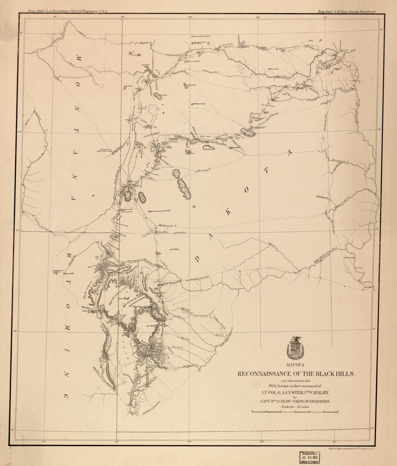
The blank was not an empty land. In his entry for July 26, 1874, that engineer, Capt. William Ludlow, put the Custer Expedition “nearly in the heart of the unexplored portion of the hills.” That day the column came on an Oglala camp of seven lodges. Lt. Col. George Armstrong Custer wanted the families to stay and show the soldiers the country. They slipped away instead, and their headman, One Stab, was held as guide and hostage. That summer Samuel Hinman, crossing the southern Hills, described the Red Valley as the tribes’ great trail around them, the Park Service’s 2003 Wind Cave study notes.
Odometers and Star Sights: The 1874 Map
Ludlow’s men measured the march as they went. Two sergeants, each with a helper, kept separate records of the route by compass and odometer, one of them with a two-wheeled odometer cart built for the job. Chronometers, a small transit and a sextant fixed every camp but ten by astronomical sightings. Ludlow found that Warren had placed Black Elk Peak (called Harney Peak until 2016) six or seven miles too far east. Ludlow erred too: near the summit he judged he stood some 9,700 feet above the sea.
The column marched across the Great Sioux Reservation, which the 1868 treaty had set apart for the tribes, and its gold reports drew miners onto that land. Its story is told on The Custer Expedition of 1874.
The 1875 Survey Fills In the Interior
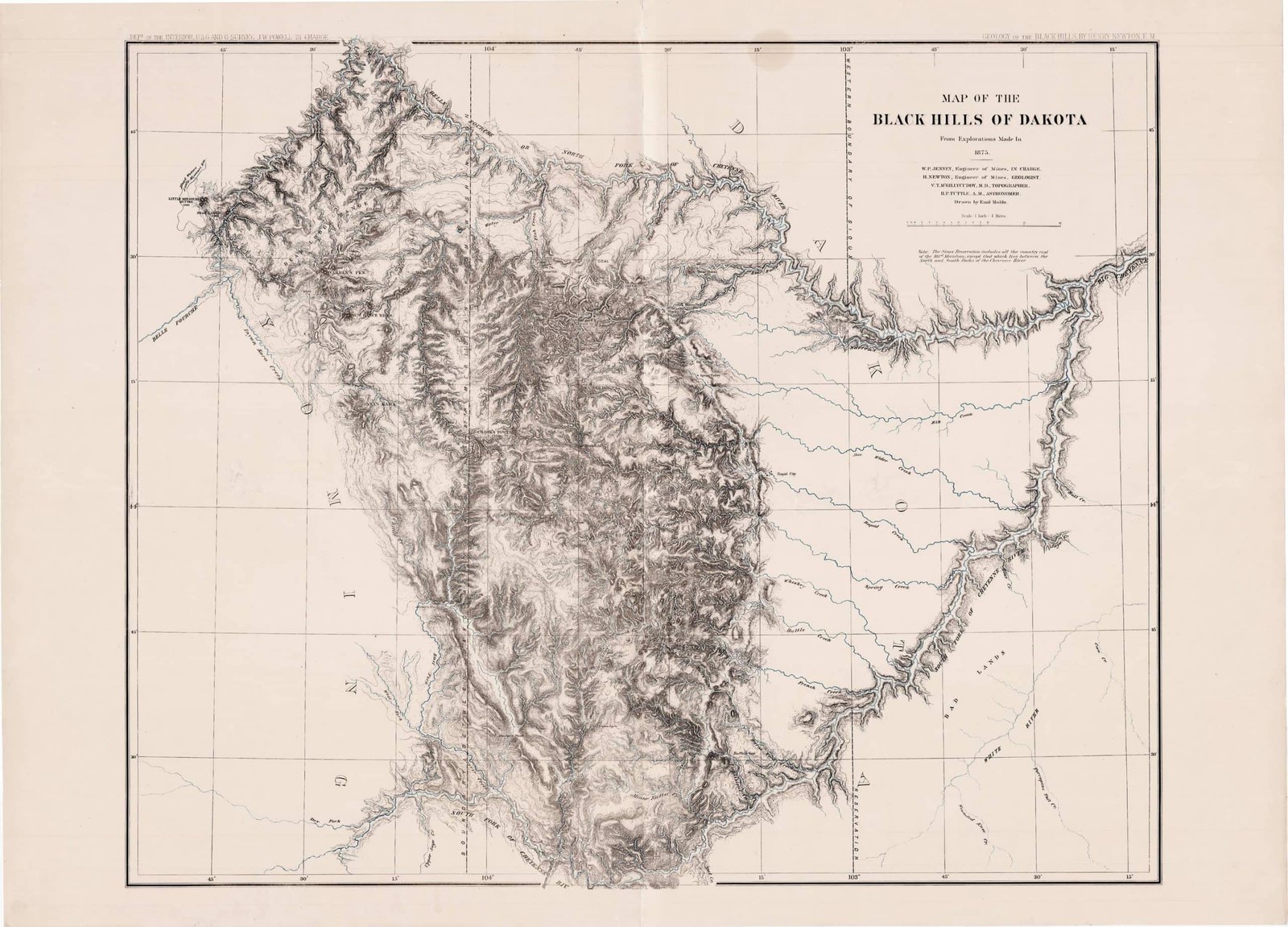
The next survey came in 1875, for the Interior Department. Its job, its report says, was to learn the truth about the gold, as a basis for any later negotiation with the tribes for the land. Walter P. Jenney, an engineer of mines, led it, with Henry Newton as geologist. Because Warren’s and Raynolds’s maps showed only the outer rim, the party added a topographer, Dr. V. T. McGillycuddy, and an astronomer, Horace P. Tuttle.
McGillycuddy crossed and recrossed the Hills, sketching as he rode, judging distance by his traveling time and taking bearings by compass. Tuttle took the latitude with a sextant each night, a triangulation among the main peaks tied the work together, and longitude was later set by telegraph. On July 25, 1875, Tuttle read his barometers atop Black Elk Peak and worked out 7,369 feet, a figure, he noted, far from Ludlow’s.
The map that came of it names the survey’s leaders in its title block and says it was drawn by Emil Mahlo; the report’s editor credited McGillycuddy with drawing it. By the time it was printed, a note in its corner put the reservation east of the 103rd meridian, and a dashed line marked that new boundary on the plains east of the Hills. The line was the 1877 Act’s. The Hills had been taken from the tribes without the consent the Fort Laramie Treaty of 1868 required.
Newton’s Geological Map and Bird’s-Eye View
Henry Newton never saw these maps in print. Back in the Hills in 1877 to recheck his work, he caught typhoid fever and died at Deadwood on August 5, 1877. The geologist G. K. Gilbert edited the report from his unfinished draft. Its atlas was printed in New York in 1879, and the report came out in 1880.
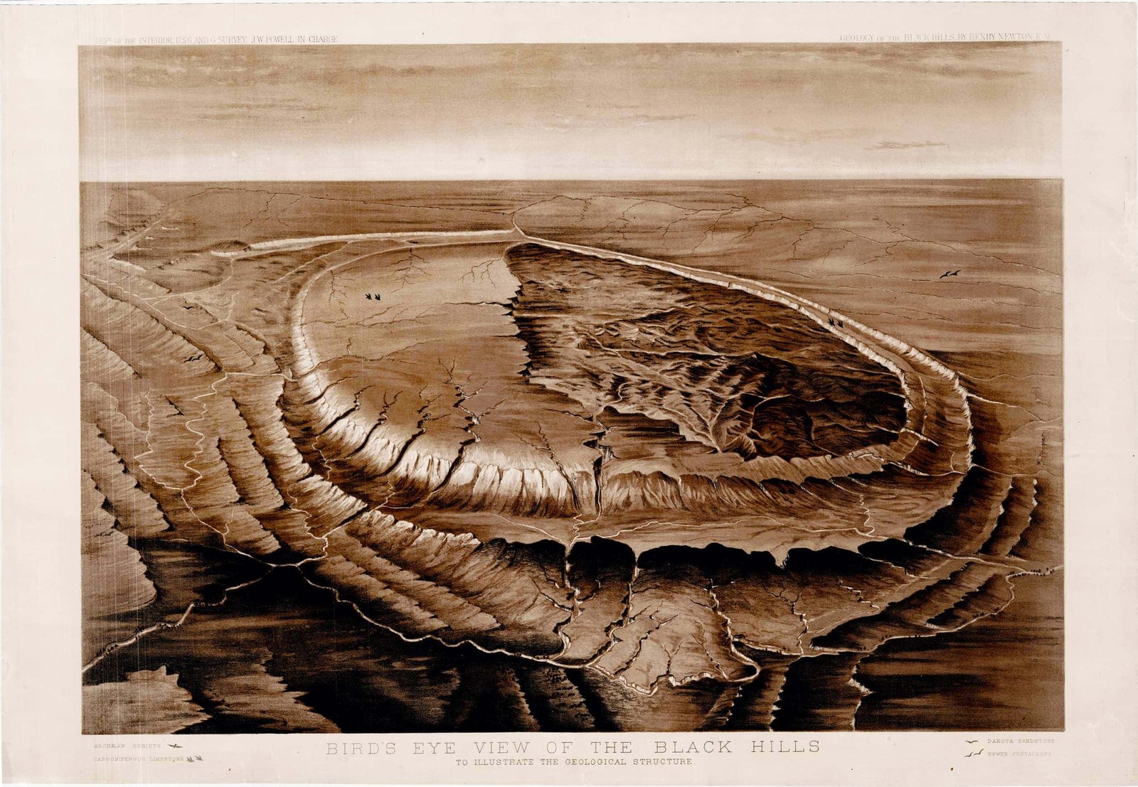
Gilbert was frank about the geological map. Newton had roughed out the rock formations on a small preliminary map, and the large one was printed too late for him, so Gilbert copied the colors over and filled in details from the text, expecting he had made errors Newton would have avoided. He also struck one mistake of Newton’s and Jenney’s, the idea that all the creeks’ loose gold came from quartz ledges in the oldest rocks. The bird’s-eye view was Newton’s design, drawn under his eye but engraved after his death.
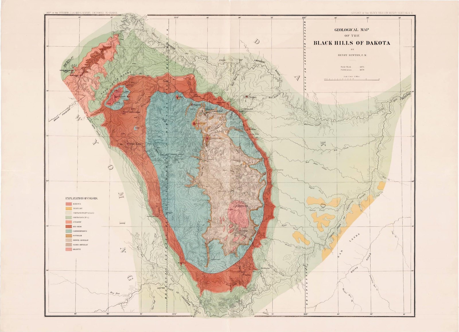
The broad picture held. In 1909 N. H. Darton of the U.S. Geological Survey wrote that Newton, in one short season and under hard conditions, had worked out most of the broader features of the Hills, and he called the report a standard work. Newton’s map shows the same pattern, granite and old schist at the center, then limestone, red beds and sandstone, that is laid out on How the Black Hills Formed.
Maps for Miners, and Maps by the Tribes
Once the rush began, maps were made to sell. Rand, McNally & Co.’s 1877 map of the northern Black Hills, from a survey by Maj. George Henckel, laid out the mining districts of the gold rush and indexed their gold- and silver-bearing lodes.
Tribal maps existed too, seldom seen by outsiders. At the end of the 1800s the Oglala artist Amos Bad Heart Bull (1869 to 1913) drew one naming places in and around the Hills, among them Bear Butte, Bear Lodge Butte, the Buffalo Gap and the Racetrack, the Red Valley that circles the Hills, the Park Service’s 2003 study records. The study calls it one of the earliest tribal sources to record sites the Lakota and Cheyenne held sacred, and says it was little known until Helen Blish published a copy in 1967, in A Pictographic History of the Oglala Sioux. The same study cites statements filed in 1986 with the Senate testimony of the Lakota scholar Charlotte Black Elk, which described two buffalo robes, kept secret until then: one maps places in the Hills, the other the stars tied to them (see Hé Sápa: Why the Hills Matter).
Contour Lines and Quadrangles
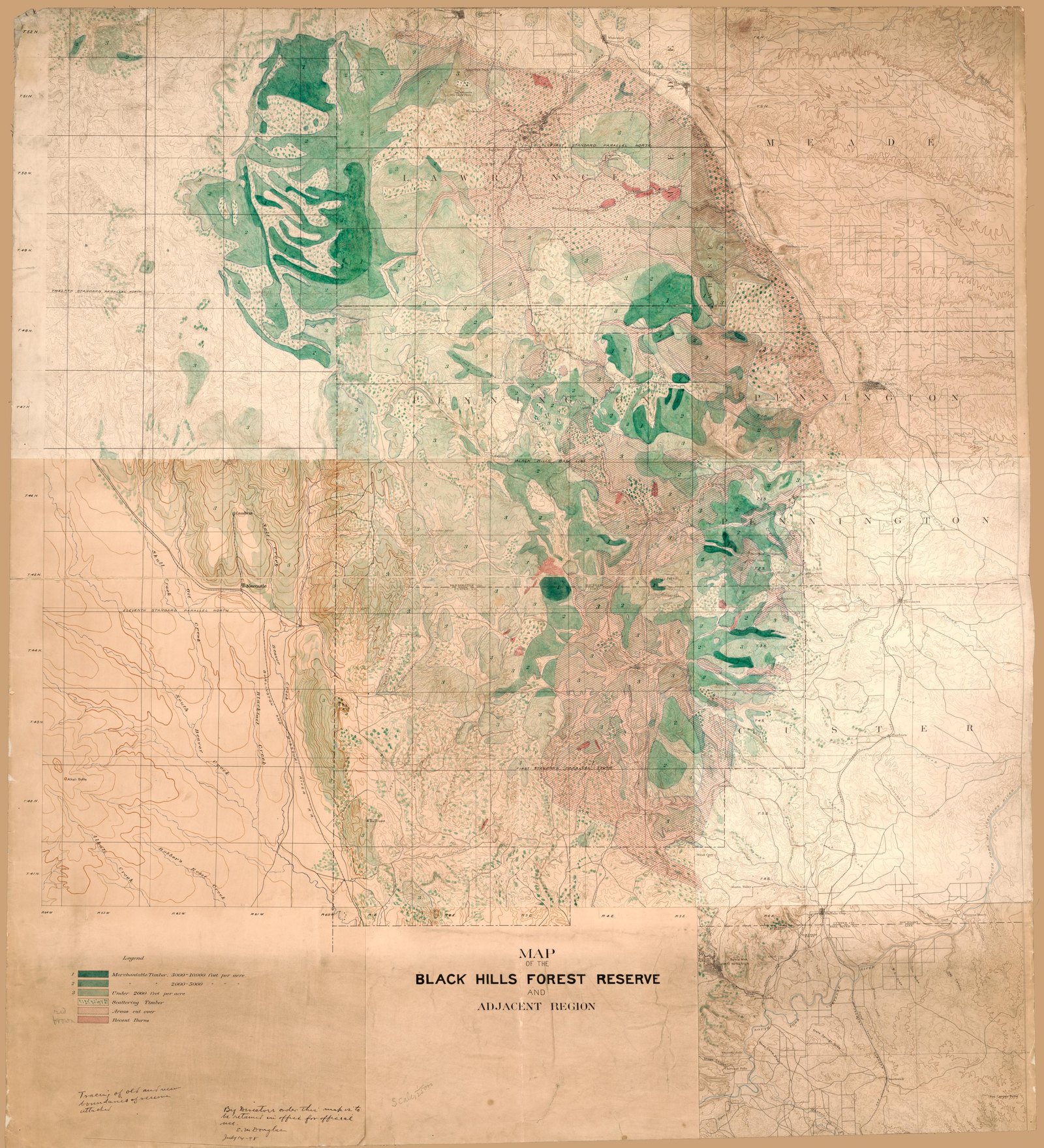
The U.S. Geological Survey’s map of the Black Hills Forest Reserve, made about 1897, the year the reserve was proclaimed, shows timber colored by hand over a printed topographic map, the ground drawn in contour lines. The Survey’s geologic folios mapped the country in blocks called quadrangles; Darton’s Sundance quadrangle of 1905, a quarter of a square degree, runs about 34 miles north to south and 25 across.
The highest peak’s height took decades to settle. Ludlow’s 9,700 feet and Tuttle’s 7,369 gave way to Darton’s 7,216 in 1905; the figure the Geological Survey has long published is 7,242 feet. The surveyors from 1857 to 1905 all called it Harney’s Peak or Harney Peak. How it became Black Elk Peak, and what Lakota speakers call it, is told on Black Hills Place Names and Where They Came From.
Connected
- The Custer Expedition of 1874The march Ludlow mapped, and the gold it reported on treaty land.
- The Fort Laramie Treaties of 1851 and 1868The treaty that set apart the land the 1874 and 1875 surveyors mapped.
- The Black Hills Gold RushThe rush that followed the 1874 gold reports, and the districts on the 1877 map.
- How the Black Hills FormedThe rings of rock that Newton’s geological map colored.
- Black Hills Place Names and Where They Came FromHarney Peak, Bear Lodge, Inyan Kara and the other names on these maps.
- A Black Hills TimelineWhere the surveys fall among the other dates of the Hills’ history.
- Hé Sápa: Why the Hills MatterThe Lakota robes that map the Hills and the stars tied to them.
- Who Lived in the Hills FirstThe people of the Hills long before any map was drawn.
Further reading
- A Pictographic History of the Oglala Sioux, drawings by Amos Bad Heart Bull, text by Helen H. Blish, University of Nebraska Press, 1967 (Internet Archive lending copy)
- Standing in the Light: A Lakota Way of Seeing, Severt Young Bear and R. D. Theisz (free online edition)
- The Home of the Bison, vol. 1, National Park Service, 2003 (Bad Heart Bull’s map, pp. 482–483)
- Preliminary Report of Explorations in Nebraska and Dakota, in the Years 1855–’56–’57, G. K. Warren, Internet Archive (the 1857 objections, pp. 18–21)
- Topographical and Geological Atlas of the Black Hills of Dakota, Library of Congress (with Newton and Jenney’s report)
Sources
- Preliminary Report of Explorations in Nebraska and Dakota, in the Years 1855–’56–’57 (G. K. Warren). Engineer Department, U.S. Army, 1858, reprinted 1875 (Internet Archive).
- Exploring the Black Hills, 1855–1875: Reports of the Government Expeditions; The Dacota Explorations of Lieutenant Gouverneur Kemble Warren, 1855–1856–1857 (James D. McLaird and Lesta V. Turchen). South Dakota History 3, no. 4, South Dakota State Historical Society, 1973.
- About the Name. National Park Service, Devils Tower National Monument, 2025.
- Report of a Reconnaissance of the Black Hills of Dakota, Made in the Summer of 1874 (William Ludlow, with the geological report of N. H. Winchell). Engineer Department, U.S. Army, 1875 (Internet Archive).
- Map of a Reconnaissance of the Black Hills, July and August, 1874, with Troops under Command of Lt. Col. G.A. Custer, 7th Cavalry (William Ludlow). Library of Congress, Geography and Map Division, 1874.
- Exploring the Black Hills, 1855–1875: Reports of the Government Expeditions (Colonel William Ludlow and the Custer Expedition, 1874) (James D. McLaird and Lesta V. Turchen). South Dakota History 4, no. 3, South Dakota State Historical Society, 1974.
- The Home of the Bison: An Ethnographic and Ethnohistorical Study of Traditional Cultural Affiliations to Wind Cave National Park, vol. 1 (Patricia C. Albers). National Park Service and University of Minnesota, 2003.
- Treaty of Fort Laramie (1868), transcript. National Archives.
- Report on the Geology and Resources of the Black Hills of Dakota, with Atlas (Henry Newton and Walter P. Jenney; edited by G. K. Gilbert). U.S. Geographical and Geological Survey of the Rocky Mountain Region, 1880 (Internet Archive).
- Report on the Geology and Resources of the Black Hills of Dakota, with Atlas: catalog record and atlas. Library of Congress, Geography and Map Division (atlas printed by J. Bien, New York, 1879).
- Geology and Water Resources of the Northern Portion of the Black Hills and Adjoining Regions in South Dakota and Wyoming (Professional Paper 65), introduction (N. H. Darton). U.S. Geological Survey, 1909 (online edition, NPS History).
- Rand, McNally & Co.’s Map of the Northern Portion of the Black Hills (George Henckel). Library of Congress, Geography and Map Division, 1877.
- A Pictographic History of the Oglala Sioux (Amos Bad Heart Bull and Helen H. Blish), catalog record. University of Nebraska Press, 1967 (Internet Archive).
- Bad Heart Bull, Amos, 1869-1913 (name authority record). Library of Congress.
- Map of the Black Hills Forest Reserve and Adjacent Region (Edward M. Douglas, U.S. Geological Survey). Library of Congress, Geography and Map Division, about 1897.
- Description of the Sundance Quadrangle (Geologic Atlas of the United States, Folio 127) (N. H. Darton). U.S. Geological Survey, 1905.
- Hydrology of the Black Hills Area, South Dakota (Water-Resources Investigations Report 02-4094) (Daniel G. Driscoll and others). U.S. Geological Survey, 2002.
Last reviewed: