Towns
Rapid City, South Dakota
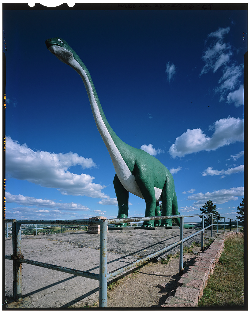
A concrete Brontosaurus has watched over downtown Rapid City since the 1930s, though nobody had found any trace of the animal in South Dakota when it went up. Barnum Brown, the American Museum of Natural History curator who advised the builders, sent its measurements from his museum's fossils in New York, the park's 1990 National Register nomination explains. The ridge beneath it is the real thing: the Hogback, the outer rim of the Black Hills. Rapid City, the seat of Pennington County and home to 74,703 people in the 2020 census, grew where Rapid Creek breaks through that ridge at the eastern foot of the Central Hills. Its story takes in an 1876 supply camp, a wartime air base, the 1972 flood and a tribal health center on an old boarding school campus.
A Ridge Down the Middle of Town
Rapid City straddles the Hogback. The ridge is the last of the four rings of rock laid out on How the Black Hills Formed, and a 2010 field guide published by the South Dakota School of Mines and Technology calls it the ridge that "more or less divides Rapid City into two parts." Its rock is mostly hard sandstone of the Inyan Kara Group, from the Lakota and Fall River formations. Skyline Drive climbs the ridge, and Dinosaur Park sits just west of the road, on a summit the nomination calls Hangman's Hill.
Works Progress Administration crews began the park's five original dinosaurs in February 1936, each a concrete skin about 4 to 5 inches thick over iron pipe and wire mesh. The park was dedicated that May 22 and was largely finished by mid-1938. That sandstone has a real dinosaur record: its Lakota layer has yielded fossils elsewhere around the Hills. One plant-eater, Dakotadon lakotaensis, dug from it east of Whitewood and brought to scientists in 1975, is kept in Rapid City at the School of Mines' Museum of Geology. Fossils and the Mammoth Site covers the other finds.
From the hilltop the city spreads both ways. East of the ridge, downtown and the prairie beyond sit on younger Cretaceous rock. West of it lies the Red Valley, cut in the red Spearfish Formation, with a pine-covered limestone ridge and the old rock of the core rising behind. Interstate 90 runs north toward Sturgis on those red beds, and gypsum from a pit beside the highway has fed a cement plant on the city's west side. The mineral can betray builders. Weathering makes it swell, and the guide blames that for cracked foundations under homes on the city's southwest side.
Hay Camp on Rapid Creek
Rapid City started as a town plan, not a mine. John R. Brennan, Sam Scott, John W. Allen and James Carney had found little gold when they agreed by a campfire on February 23, 1876, that a town might pay better, John C. Borst wrote in South Dakota History in 1984. They began laying it out two days afterward, beside Rapid Creek at the mouth of its canyon. A state marker erected in 1955, and listed in 1988 at the Halley Park museum, dates the founders' camp to February 24 and the survey of a site a mile square to the next day, with Scott as surveyor.
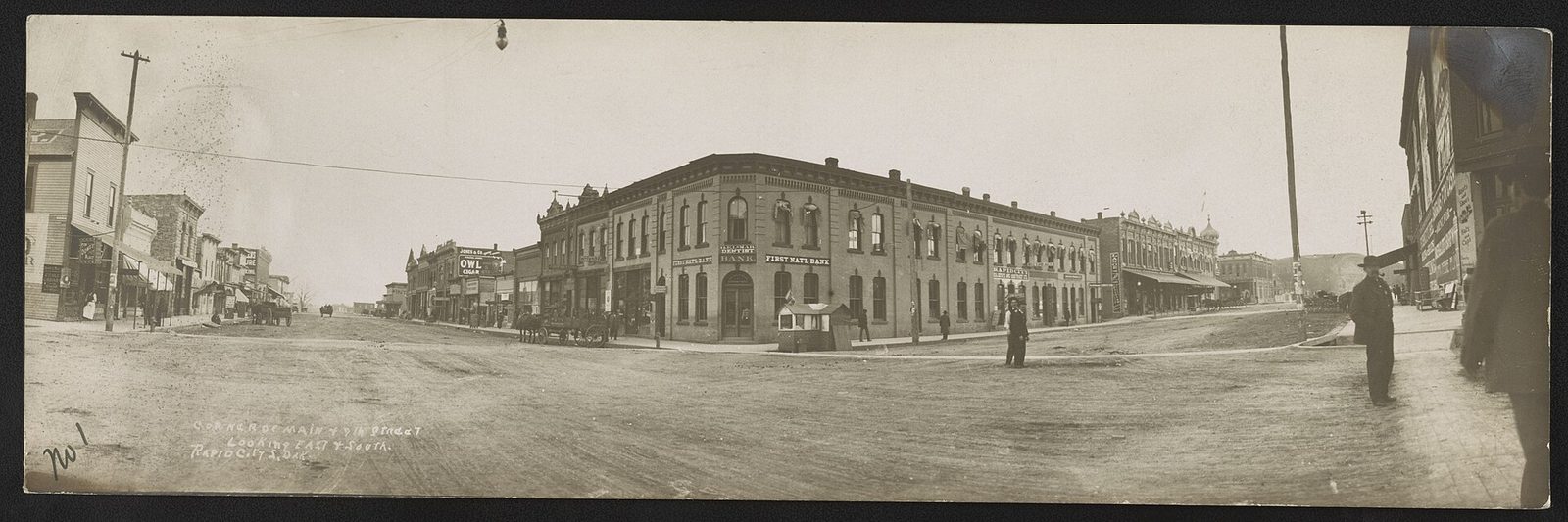
The settlers called the place Hay Camp. Wagons carrying goods to the mining camps gathered there before heading into the Hills, by the Rapid City Public Library's account; the freight trade is traced on Stagecoaches and Railroads. Rapid City became the county seat in 1877, was incorporated in 1882 and got its railroad in 1886, Britannica records. The founders built their town on reservation land that the 1877 Act took from the tribes a year later, without the consent the 1868 treaty required, a history told on The 1876 War and the Taking of the Hills.
Is Rapid City the Gateway to the Black Hills?
Only loosely, and today the phrase is a tourism promoters' line. Britannica describes the early town as "the eastern gateway to the mining region," a transport hub at the edge of the mountains. Visit Rapid City, the local tourism bureau, now presents the city as a gateway to the Black Hills. Belle Fourche's chamber of commerce claims the "Northern Gateway" for its own town. The ground offers no single entrance; Sturgis, Spearfish and Hot Springs sit in the same Red Valley.
Britannica counts tourism as the mainstay of the city's economy, and Rapid City serves the region as a center for trade, schooling and health care. The military came in January 1942, when the War Department set up Rapid City Army Air Base on the prairie east of the Hogback, next to Box Elder, to train B-17 bomber crews. It was renamed in 1953 for Brig. Gen. Richard E. Ellsworth, killed in a crash in Newfoundland that March, and its bombers and missiles are traced on Ellsworth and the Minuteman Missiles.
The Flood of June 9, 1972
On the night of June 9, 1972, Rapid Creek tore through the city in a flood that killed 238 people across the Black Hills, the toll the National Weather Service gives; a 2002 U.S. Geological Survey fact sheet cites the same figure from the Red Cross, with 3,057 injured. Rain had fallen on the eastern Hills since late afternoon, nearly 15 inches of it near Nemo. Pactola's dam held back what ran off the upper creek, the USGS found; the trouble was lower down, where the worst of the storm struck between the dam and the city. Canyon Lake's dam gave way at about 10:45 p.m., its spillway choked with wreckage the flood carried down the creek. Around midnight the creek peaked at about 50,000 cubic feet per second in town. The flood destroyed 1,335 homes and 5,000 cars, and a hospital near the creek had to move out all 90 of its patients, the Rapid City Journal reported that month.
Rapid City chose to give the creek room. The Army Corps of Engineers ruled out dams and levees because of sinkholes, the Weather Service's history says, and within two months the city began buying land for a floodway, about 750 acres in the end, with more than $12 million from the Department of Housing and Urban Development to relocate the homes and businesses displaced. The guiding idea, as the USGS gives it, was that "no one should sleep within the flood plain," so houses and motels were cleared from the floodway while many businesses stayed. That land is now the greenway, a string of parks along the creek. It includes Memorial Park, 28 acres downtown, and a 6-mile bike path named for Leonard "Swanny" Swanson, the public works director who led the recovery, according to the Rapid City Historic Preservation Commission.
Pactola also serves the city's taps: the Interior Department said in 2024 that Rapid City and Ellsworth Air Force Base get municipal water from it, and the reservoir is described on Lakes of the Black Hills.
The Boarding School Hillside
"Our families and our community never forgot them," Amy Sazue, who is Lakota and directs the Rapid City Indian Boarding School Memorial Project, said in 2022, as ICT reported. Sazue was speaking of the children who died at the federal boarding school that ran in Rapid City from 1898 to 1933. Volunteer researchers working from school records and interviews with elders have identified at least 50 of them, and they believe a hillside near the old school holds unmarked graves. In 2022 the project was planning its memorial for that hillside.
The campus later held a tuberculosis center and then the Sioux San Hospital, Jerilyn Church, who leads the Great Plains Tribal Leaders Health Board, told SDPB in 2023. Acting for the Cheyenne River, Oglala and Rosebud tribes, the board runs the Oyate Health Center there. It took over part of the Indian Health Service's care in Rapid City in 2019 and all of it on February 26, 2022, the health service announced, and a new building opened on the old campus in west Rapid City the next year. Church said the center stands for "a new era of tribally managed health care."
Connected
- The Central HillsThe region Rapid City sits at the foot of, from Black Elk Peak to the reservoirs.
- The Red ValleyThe red Spearfish beds and gypsum under the city's west side.
- Fossils and the Mammoth SiteThe real dinosaurs of the Hogback, and the Dinosaur Park statues.
- Ellsworth and the Minuteman MissilesThe 1942 air base east of the city and the missile field it ran.
- Lakes of the Black HillsPactola and the other reservoirs on Rapid Creek and its neighbors.
- Stagecoaches and RailroadsThe ox trains that unloaded at Hay Camp, and the 1886 railroad.
- Box Elder, South DakotaThe prairie town beside the air base, east of the Hogback.
- The 1876 War and the Taking of the HillsHow the land under the 1876 townsite was taken from the tribes.
- Where the Hills’ Water Comes FromWhich aquifers and reservoirs supply the towns, and how they hold up.
Sources
- Dinosaur Park, National Register of Historic Places Registration Form (Carolyn Torma, State Historical Preservation Center). National Park Service, 1990.
- Geologic Field Trips in the Black Hills Region, South Dakota (Bulletin No. 21), M.P. Terry, E.F. Duke and J.A. Tielke, editors; road logs by M.P. Terry, J.A. Redden and S. Allard; M.P. Terry and C.J. Paterson; and L. Stetler, A. Lisenbee, K. Katzenstein and J. Epstein. South Dakota School of Mines and Technology, 2010.
- Insight on the Anatomy, Systematic Relationships, and Age of the Early Cretaceous Ankylopollexian Dinosaur Dakotadon lakotaensis (Clint A. Boyd and Darrin C. Pagnac). PeerJ, 2015.
- Dakota Resources: The John R. Brennan Family Papers at the South Dakota Historical Resource Center (John C. Borst). South Dakota History 14, no. 1, South Dakota State Historical Society, 1984.
- South Dakota State Historical Society Markers (marker 118, Rapid City Founders Camp Site). South Dakota State Historical Society.
- History of Rapid City. Rapid City Public Library.
- Rapid City. Encyclopaedia Britannica.
- Rapid City History & Facts. Visit Rapid City (tourism bureau, cited for its own wording only).
- Nearby Communities. Belle Fourche Chamber of Commerce (marketing page, cited for its slogan only).
- A History of the Ellsworth Air Force Base. SDPB, 2023.
- The 1972 Black Hills–Rapid City Flood Revisited (Fact Sheet FS-037-02) (Janet M. Carter, Joyce E. Williamson and Ralph W. Teller). U.S. Geological Survey, 2002.
- The Black Hills Flood of 1972. National Weather Service, Rapid City office, 2021.
- 1972 Flood History. Rapid City Historic Preservation Commission.
- Hospitals Put Disaster Plans in Operation (Harold Higgins). Rapid City Journal, June 26, 1972; republished by Monument Health.
- Biden-Harris Administration Finalizes Protections for the Pactola Reservoir–Rapid Creek Watershed. U.S. Department of the Interior, 2024.
- Remembering the Children Memorial Gets $2 Million Grant (Stewart Huntington). ICT, 2022.
- Tribal Sovereignty Embraced in New Oyate Health Center (C.J. Keene). SDPB, 2023.
- IHS Rapid City Service Unit Transfer to the Tribally Managed Oyate Health Center. Indian Health Service, 2022.
Last reviewed: