Land and Water
Where the Black Hills’ Water Comes From
On August 19, 2026, Rapid City raised Pactola Reservoir’s storage condition from “concern” to “alert” and made its odd-even lawn-watering schedule year-round. The reservoir was still about three-quarters full. The trigger was the water flowing in: inflows to the reservoir were 18.5 cubic feet per second that morning, against an August average of 50. This page covers where the water of the Black Hills and the plains around them comes from, who drinks what, how the dry years and growth strain it, and what is proposed to add to it. It is mostly reporting. The few judgments are in the last block.
Two Aquifers and a Creek
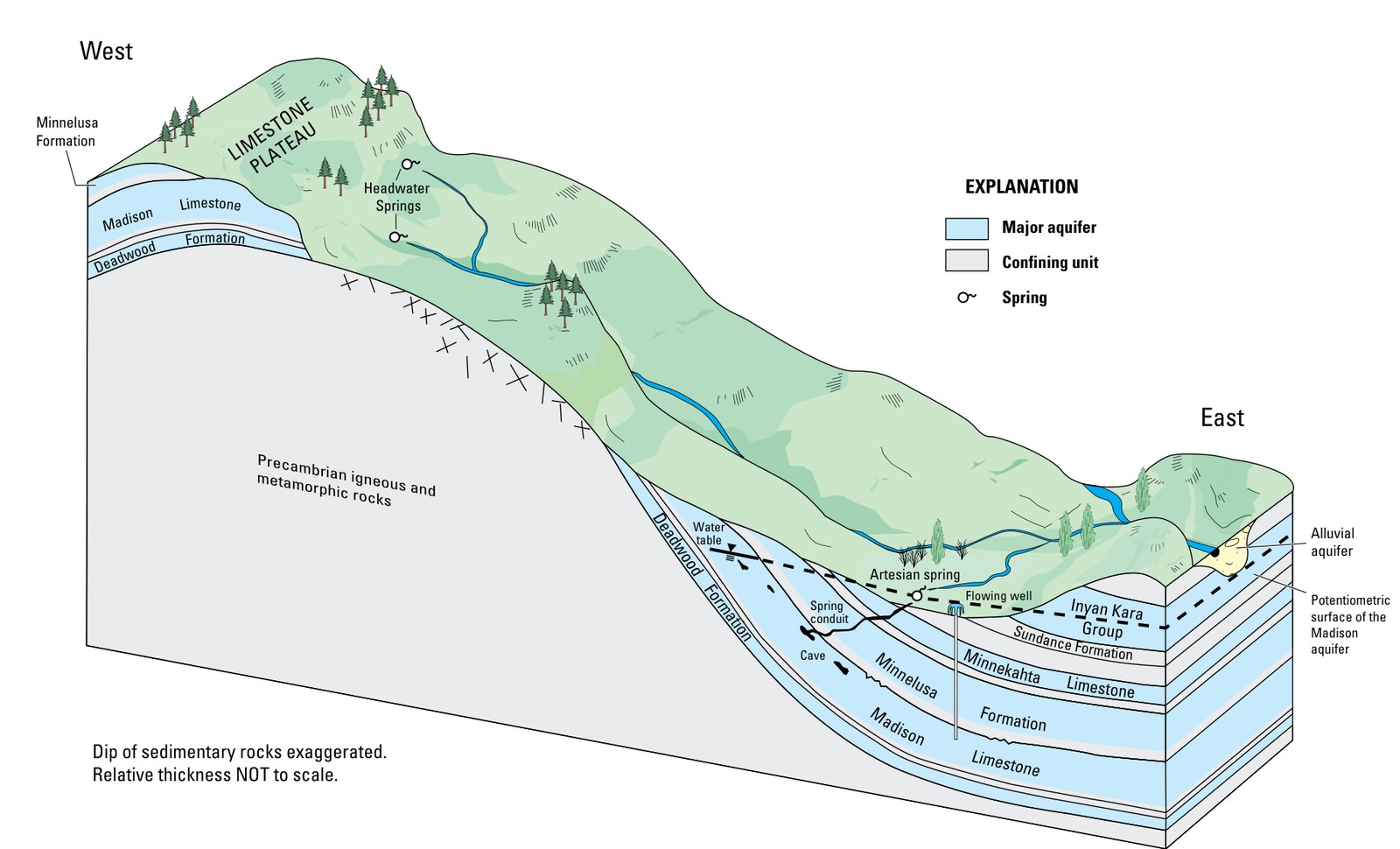
Most of the Hills’ water comes from the Madison and Minnelusa aquifers underground and from Rapid Creek and the reservoirs on it. Both aquifers refill on the outcrop, the ring of exposed rock around the high Hills: rain and snowmelt soak in, and streams crossing it sink into the limestone. The rock itself is the subject of The Limestone Plateau and the Caves.
The U.S. Geological Survey (USGS) has measured the budget twice. Its Black Hills Hydrology Study put the two aquifers’ recharge at 395 cubic feet per second for water years 1987 to 1996, with 189 leaving as artesian springflow and 28 pumped from wells. A 2025 update, made with the Western Dakota Regional Water System and covering 1931 to 2022, widened the view to six aquifers and the Wyoming side. Inflows averaged 278,900 acre-feet a year: 205,100 from precipitation and 73,800 from streams losing water into the rock. The Madison took in 57,000 acre-feet of the precipitation and the Minnelusa 98,100, together 76 percent of the precipitation recharge to all six aquifers. Their artesian springs, such as the ones that feed Hot Springs, averaged 166,100 acre-feet a year. Wells took about 50,000 acre-feet a year in 2003 to 2022.
Rapid Creek and Pactola Reservoir
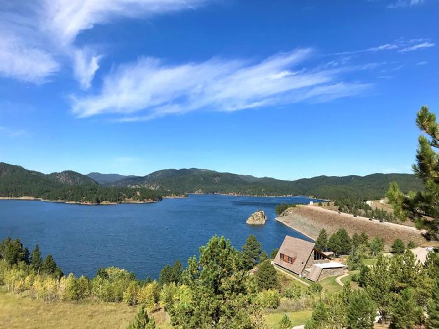
Pactola Dam, on Rapid Creek about 15 miles west of Rapid City, was built by the Bureau of Reclamation between November 1952 and August 1956; water became available on May 1, 1958. The reservoir holds 99,000 acre-feet in all. Of that, 55,000 acre-feet is conservation storage and 43,000 is flood-control space run by the Army Corps of Engineers. Reclamation says the reservoir supplies the major part of Rapid City’s municipal water, including Ellsworth Air Force Base, and supplements irrigation for 8,900 acres in the Rapid Valley Water Conservancy District. Pactola is 150 feet deep at most, the largest and deepest reservoir in the Black Hills National Forest. Black Hills Lakes covers who built the others and what they allow on the water.
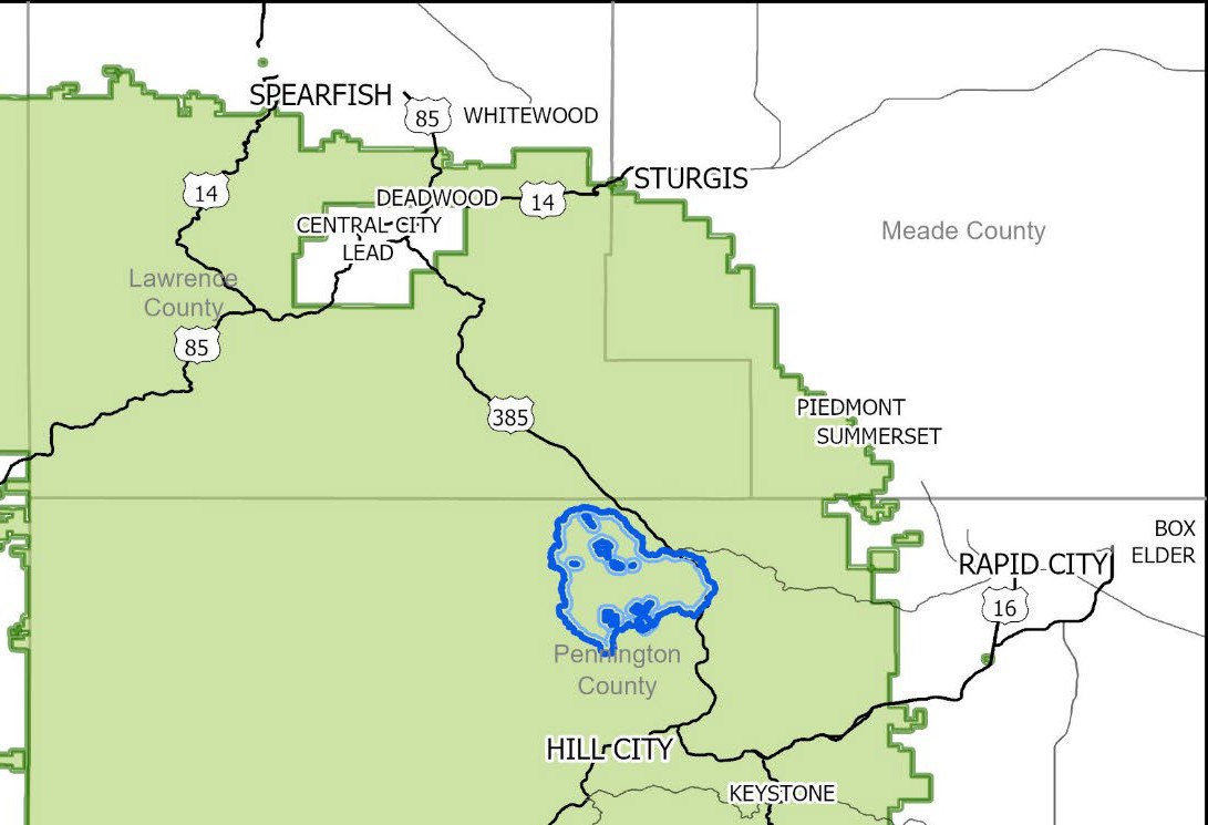
The Interior Department withdrew about 20,510 acres of national forest around Pactola and Rapid Creek from sale, exchange, mineral entry and leasing for 20 years on December 26, 2024. Its release says the withdrawal responds to requests to protect the municipal water supplies of Rapid City and Ellsworth, and names the Seven Council Fires and several other tribes as considering the area sacred. Only Congress can make such a withdrawal permanent.
Who Drinks From What
Rapid City, the region’s largest user, draws on both sources. KOTA reported in August 2025, from the city’s analysis, that about 83 percent of the city’s water rights portfolio is surface water in the Pactola and Deerfield reservoirs and about 17 percent is groundwater from the Madison and Minnelusa aquifers, and that the portfolio is estimated to support growth for the next 100 years. The city’s master plan projects adequate freshwater through 2115, mainly from Pactola and Deerfield, SDPB reported in August 2026.
Sturgis pumps groundwater. The city said in April 2026 that its water comes from local wells. The warm springs at Hot Springs are Madison water rising on its own. This guide has not confirmed the sources for Spearfish, Custer, Belle Fourche, Lead or Deadwood; each city’s annual drinking-water report names its own.
How Dry Have the Dry Years Been?
Pactola has hit record lows in 1962, 1991 and 2008, KOTA reported in August 2026, and Rapid City’s water superintendent recalled in 2022 the early-1990s drought, when the reservoir dropped by tens of feet. The record is not all one way. After two dry years, Pactola stood at 99.7 percent of capacity in May 2022.
In spring 2025, low water led Rapid City to impose restrictions weeks earlier than usual; heavy rain in July and August then raised levels. In 2026 the watershed was in extreme drought, and July inflows were 30 percent of average. Officials said restrictions would last until inflows rise substantially, which was unlikely before this winter’s snowpack was known. Boyda and Reclamation engineer Ron Bengs, speaking in August 2026, said they were watching long-term needs and voiced no open worry about the current situation; Bengs described a buffer of flood pool from wetter years that protects drinking water and downstream contract holders.
Is Growth Outrunning the Aquifers?
The Black Hills region has grown about 39 percent since the early 2000s, the USGS says. After the 2025 report, news coverage said water use in parts of the Madison and Minnelusa now exceeds recharge, in a belt from Box Elder through Rapid City and Summerset to Sturgis. James Jones, an engineer with the firm AE2S, said his firm does not consider that level of growth and use of the Madison sustainable.
The USGS abstract is narrower than the headlines. Actual well withdrawals averaged about 50,000 acre-feet a year in 2003 to 2022 and did not rise with population. Mean and maximum withdrawals exceeded recharge only for the Deadwood aquifer in one subarea and the Inyan Kara in another. The warning is in water rights: total appropriations, the amounts permits allow, exceed recharge in the Rapid City area for the Madison, Minnelusa and Inyan Kara. That is a ceiling on paper, not yet a measured drawdown. Answering the report in August 2025, Rapid City said its water rights are enough for 100 years of growth.
The Missouri River Pipeline
The proposal is a pipeline from the Missouri River to western South Dakota: 161 miles of 72-inch pipe lifting water 2,000 feet, at a cost of about $2 billion. A 2019 South Dakota Mines study, commissioned by the West Dakota Water Development District, found that supplies in the Hills would fall short in a drought and that the pipeline was feasible. The Western Dakota Regional Water System, a nonprofit formed in September 2021, leads the effort; 47 cities and water systems had signed on as of 2025.
Its backers say the region lacks a reliable long-term supply and faces growing pressure on its aquifers, and they point to the Lewis & Clark Regional Water System, launched in 1990 and serving about 350,000 people in three states, as a model. The open questions are cost, a route that KOTA reported in February 2025 had not been mapped, and time: the system’s director has said the project could take two decades or more.
The state side is settled for now. The Legislature approved Senate Joint Resolution 501 in March 2025, and the state Water Management Board approved a future-use permit for up to 20,765 acre-feet a year, reported in May 2025. Federal money is the open step. As of July 21, 2026, bills by Senators John Thune and Mike Rounds providing $10 million each for federal feasibility studies of this system and of the Dakota Mainstem system had cleared a Senate committee in June, and a third, for the Lewis & Clark system, followed in July. The system’s website says its study was awaiting a Senate vote as of September 17, and a news item it lists, dated October 23, 2026, says service would not begin for another 20 to 30 years.
What Mining Draws and Discharges
Mining touches these waters in two ways. At the Wharf gold mine near Lead, the state board approved a 50-acre expansion on July 20, 2023, extending the mine’s life to 2030. Testing had found selenium in False Bottom Creek above EPA limits; the board held that this should not stall approval. Details are on Gold, Lithium and the New Mining Rush.
The proposed Dewey-Burdock uranium project near Edgemont would use in situ recovery, pumping solutions through the uranium-bearing Inyan Kara aquifer. In November 2020 EPA issued permits for injection wells, deep disposal wells into the Minnelusa and an aquifer exemption in the Inyan Kara. As of October 28, 2026, its owner, Powertech (USA), a subsidiary of enCore Energy, was seeking state water-rights permits to draw from the Inyan Kara and the Madison, “billions of gallons per year,” with a hearing set for December 2 in Pierre. The Madison is also a source of public drinking water. See Uranium Mining Around the Black Hills.
Connected
- The Limestone Plateau and the CavesThe Madison Limestone that holds the main aquifer.
- Black Hills LakesPactola, Deerfield and the other reservoirs.
- Rapid City, South DakotaThe largest user of Pactola water.
- Hot Springs, South DakotaA town built on Madison springs.
- Uranium Mining Around the Black HillsIn situ recovery and the aquifers.
- Gold, Lithium and the New Mining RushWharf, exploration and the Pactola withdrawal.
- Oil Pipelines and the RiversPipelines and drinking-water sources.
Local organizations
- Honor the Earth, an Indigenous-led organization that describes itself as “committed to protecting the lifeways and sovereignty of our Indigenous Relatives across Mother Earth.”
Sources
- Hydrologic budgets and water availability of six bedrock aquifers in the Black Hills area, South Dakota and Wyoming, 1931–2022 (Scientific Investigations Report 2025-5067). U.S. Geological Survey, 2025.
- Hydrologic budgets for the Madison and Minnelusa aquifers, Black Hills of South Dakota and Wyoming, water years 1987–96 (Water-Resources Investigations Report 01-4119). U.S. Geological Survey, 2001.
- Rapid Valley Unit. Bureau of Reclamation.
- Biden-Harris Administration Finalizes Protections for the Pactola Reservoir–Rapid Creek Watershed. U.S. Department of the Interior, December 26, 2024.
- Rapid City Extends Water Restrictions Year-Round as Pactola Reservoir Inflows Plummet. KOTA, August 19, 2026.
- Rapid City watershed could last a century if properly managed, officials say. C.J. Keene, SDPB, August 4, 2026.
- Rapid City assures community they have reliable water service in light of federal study. KOTA, August 28, 2025.
- Pactola Reservoir shows promising signs amidst two-year drought in the Black Hills. KOTA, May 13, 2022.
- Black Hills, South Dakota Region Faces Severe Water Shortages. South Dakota News Watch, via Insurance Journal, August 13, 2025.
- Black Hills water study and the Missouri River pipeline. Bart Pfankuch, South Dakota News Watch, 2025.
- Legislature weighing future use of Missouri River water for Western SD. KOTA, February 11, 2025.
- South Dakota approves WDRWS water permit for future use. South Dakota Ag Connection, May 12, 2025.
- Senate committee advances bill supporting study of Missouri River pipeline system expansion. South Dakota Searchlight, via States Newsroom, July 21, 2026.
- Western Dakota Regional Water System. Western Dakota Regional Water System, viewed November 2026 (the project’s own account).
- South Dakota pipeline project faces delays as officials warn of growing water supply risk. Underground Infrastructure, April 23, 2026.
- City of Sturgis releases annual drinking water report. City of Sturgis, April 29, 2026.
- Board approves expansion of Wharf Mine. SDPB, July 20, 2023.
- EPA issues permits for Dewey-Burdock uranium recovery project near Edgemont, South Dakota. U.S. Environmental Protection Agency, November 24, 2020.
- Public comment period opens as company seeks state permits for uranium mine. South Dakota Searchlight, via States Newsroom, October 28, 2026.
Last reviewed: