Towns
Spearfish, South Dakota
Spearfish Creek leaves its canyon with an unusually steady flow. In ordinary times it carried 50 to 100 cubic feet a second and seldom dropped below 50, the USGS geologist N.H. Darton reported in 1909. Spearfish, South Dakota, grew where the creek crosses the Red Valley on the northern edge of the Black Hills, and with 12,193 people in the 2020 census it is the largest town in the Northern Hills. The creek ran through much of what the town lived on: farms, a federal trout hatchery and a gold mine's power plants. A teachers' school founded in 1883 became Black Hills State University, and for nearly 70 summers a passion play filled a hillside at the edge of town.
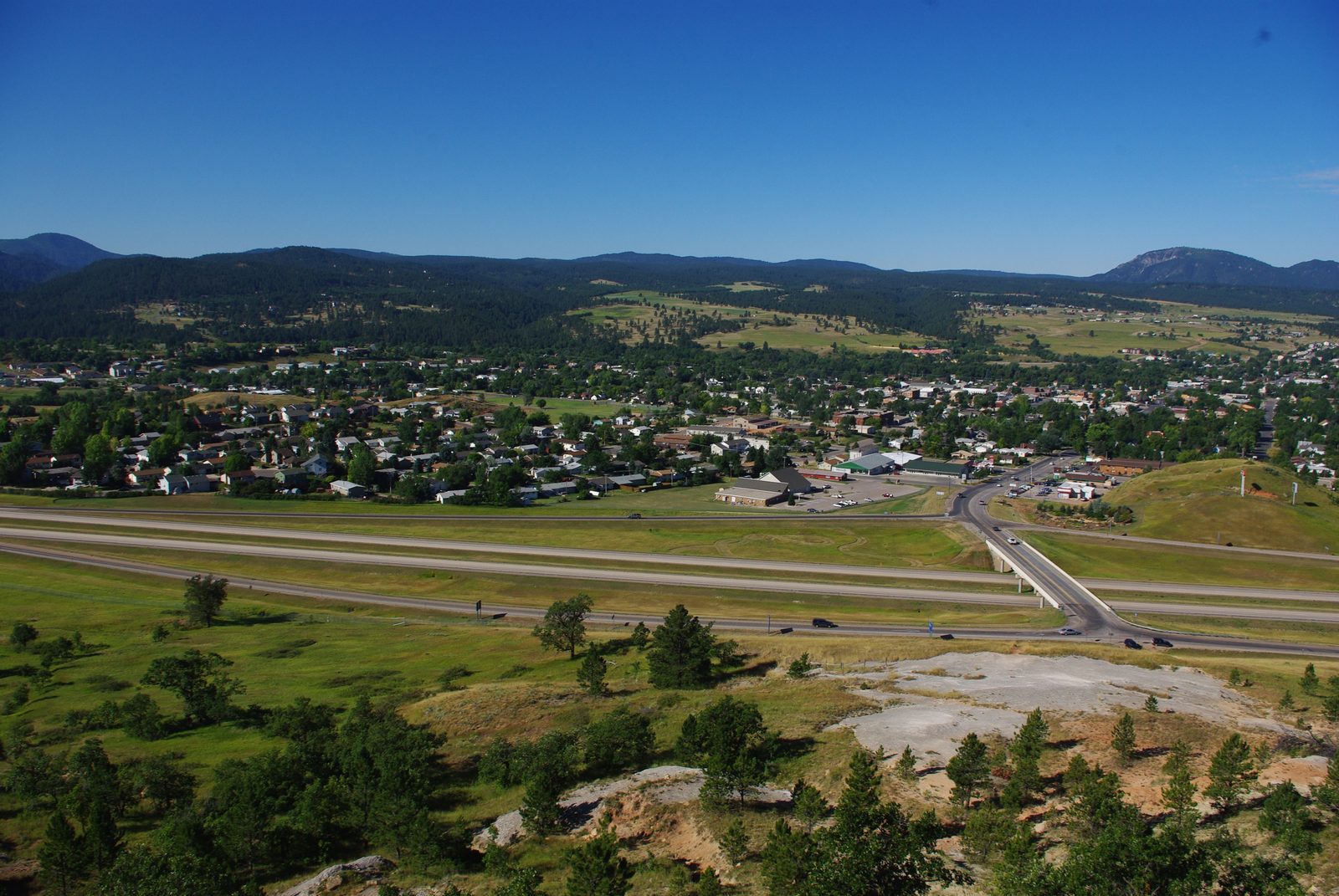
Red Beds at the Canyon's Mouth
Spearfish sits on the third of the four rings of rock that make up the Black Hills. Between the forested Limestone Plateau and the sandstone Hogback, a band of soft red rock has worn down into a lowland, which Darton described in 1909 as running unbroken around the uplift. The rock is the Spearfish Formation: red shale, siltstone and sandstone with beds of white gypsum, 450 to nearly 700 feet thick in the northern Hills and roughly 250 to 200 million years old, from the end of the Permian period into the Triassic. Darton named it in 1899, probably after the town.
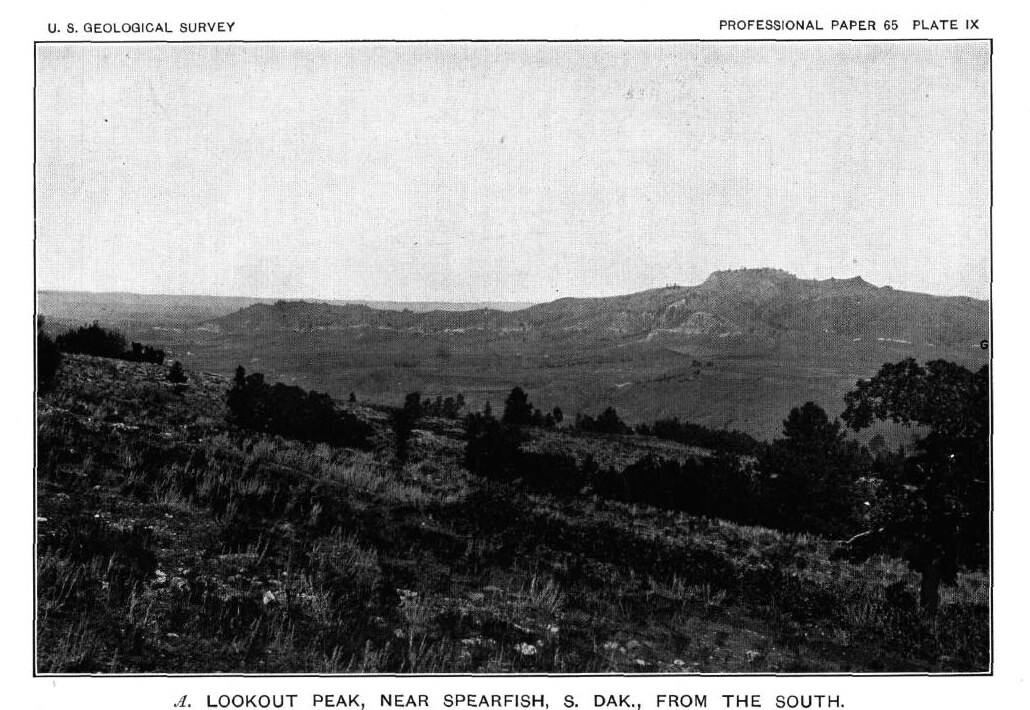
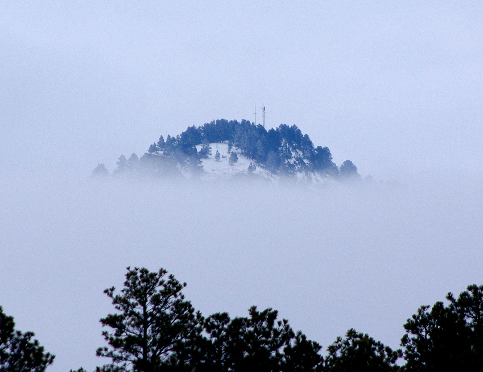
The red ground and its gypsum show along much of Interstate 90 between Rapid City and Spearfish, a 2010 field guide by South Dakota geologists points out. Near town the red beds climb Lookout Mountain, the ridge on the east side of Spearfish, where pale ledges of gypsum stand out on its slopes. Darton, who called it Lookout Peak, put that gypsum in the Spearfish Formation and recorded one bed 18 to 20 feet thick; geologists now disagree about which layer it belongs to, as The Red Valley explains. That page also tells the Lakota and Cheyenne story of a great race that gave the valley its other name, the Racetrack.
South of town the creek leaves Spearfish Canyon, the gorge it cut through the plateau between tall walls of limestone. So the town stands where two rings of the Hills meet: the red floor of the valley and, upstream, the gray cliffs of the plateau. Why creeks that cross this limestone can lose their water underground is explained on The Limestone Plateau and the Caves.
A Townsite on the Creek in 1876
Two townsite speculators, Alfred Gay and J.E. Smith, laid out Spearfish beside the creek in the spring of 1876, during the Black Hills gold rush, and gave it streets and alleys wider than most. The records disagree on the day. A 1975 National Register nomination for the downtown says March 29, while the Black Hills State University library, which marked the town's 150th anniversary in 2026, gives May 29. Spearfish incorporated as a city in 1888, a year before South Dakota became a state.
The valley had drawn notice before the town was laid out. A Chicago Tribune reporter who saw it in 1875 wrote that "everyone has remarked the beauty and fertility of this valley," the university library's anniversary guide records. The townsite lay on land the 1868 Fort Laramie Treaty had set apart for the tribes, and the 1877 Act took the Hills without the consent the treaty required, as The 1876 War and the Taking of the Hills explains.
Farms, Trout and a Teachers' School
Spearfish lived at first on the people around it. With the placer gold already thinning out, the city's historic preservation commission writes, ranchers and the few miners still at it needed a town for supplies and company. Spearfish quickly became that town, a 1990 National Register form for its city hall says; a 1987 form for an old filling station adds that it came to serve one of the biggest trading areas in the Hills. Irrigation still draws on the creek, a 2006 House bill about the city's hydroelectric plant noted.
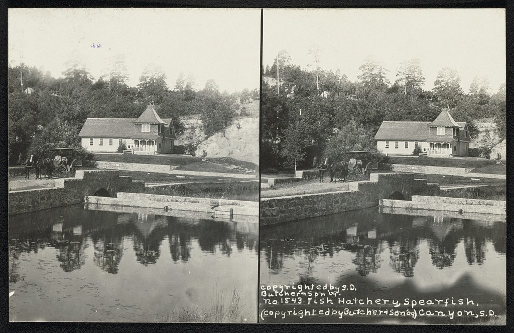
On June 11, 1896, Congress set aside $5,000 for a fish-culture station at Spearfish to raise and stock trout for the Black Hills. Federal officials accepted the new hatchery building in July 1899, and by July 29 that year 100,000 trout eggs were incubating in cold spring water carried in by gravity, the U.S. Fish and Wildlife Service says. DeWitt Clinton Booth, the first superintendent, came that year and ran the station for 34 years. Budget cuts closed it in the early 1980s; it reopened in 1984 under his name. The D.C. Booth Historic National Fish Hatchery, at the south end of town, keeps the 1905 Booth House, a restored 1910 fisheries railroad car and the agency's national archive of fisheries records and artifacts.
In 1881 the Dakota Territorial Legislature offered to fund a school for training teachers if Spearfish and its neighbors deeded at least 40 acres to the territory, and the Dakota Territorial Normal School was founded in 1883. Fire destroyed its main building, Old Main, on January 13, 1925. Renamed Black Hills Teachers College in 1941 and Black Hills State College in 1964, the school became Black Hills State University in 1989. Black Hills State is now one of six public universities governed by the South Dakota Board of Regents, and it runs on state money and on its students' tuition and fees.
The creek also made electricity for the Homestake Mine at Lead, which built a hydroelectric plant on it, the 1975 nomination notes. The city bought Homestake's Spearfish Hydroelectric Plant Number 1 in 2004, once the mine had stopped producing and the company no longer needed the plant's power, Mayor Jerry Krambeck told a House subcommittee in 2006; the plant's diversion routes water past a sinkhole in the creek, where some of it would otherwise drain into the aquifer below. How the creek was put to work is followed on Spearfish Creek: Power, Rails and the 1933 Flood.
Timber still employs people here. A Spearfish sawmill announced about 50 layoffs in April 2024, leaving about 150 workers, and its owner blamed cuts in the Black Hills National Forest's timber sales, South Dakota Searchlight reported. The argument over how much the forest can sell is on Logging the Ponderosa.
A Passion Play Under Lookout Mountain
For decades, a play about the last days of Jesus was a regular stop on a Black Hills vacation, SDPB's Brian Gevik wrote in 2017. Josef Meier, born in Lünen, Germany, was the seventh generation of his family to act in passion plays, and in 1932 he brought an English version to New York with a small cast. Six years later he settled the company in Spearfish. The Black Hills Passion Play opened there in May 1939, in an amphitheater with 6,000 seats on a hillside, facing a stage 2½ blocks long with Lookout Mountain behind it. The first season drew more than 14,000 people, the South Dakota Historical Society Foundation writes.
After 9,000 performances, Josef Meier and his wife retired in 1991, and their daughter, Johanna Della Vecchia, produced and directed the play through its final season. The last performance in Spearfish came on August 31, 2008.
Canyon, Forest and the Towns Nearby
From town, the Spearfish Canyon Scenic Byway follows the creek upstream on the grade of the old canyon railroad, which flooding ended in 1933, the Forest Service says. Spearfish Canyon covers the drive, the waterfalls and the trails. The Black Hills National Forest runs its Northern Hills Ranger District from an office on North Main Street.
Interstate 90 runs east from Spearfish past Whitewood and Sturgis toward Rapid City. Belle Fourche, the old cattle and rail town, lies north on the plains past the Hogback. Up in the hills are the gold towns of Lead and Deadwood; a stage once ran between Deadwood and Spearfish. Southwest of town, within a mile of the Wyoming line, lies the old tin camp of Tinton. Many people in Spearfish once worked at the Homestake Mine in Lead, the mayor told Congress in 2006, and its story is on The Homestake Mine and Sanford Lab.
Spearfish holds a place in Black Hills weather history. On January 22, 1943, a recording thermometer in town read −4°F at 7:32 a.m. and 45°F two minutes later; the same morning, the temperature fell from 54°F back to −4°F in 27 minutes, the National Weather Service says. That morning across the Hills is told on Black Hills Weather, Climate and Seasons.
Connected
- The Northern HillsThe region Spearfish belongs to, from the gold gulches to the irrigated plains.
- The Red ValleyThe red beds of the Spearfish Formation, probably named for the town.
- The Limestone Plateau and the CavesThe limestone Spearfish Creek cut through above town, and the water it loses underground.
- Spearfish CanyonThe canyon south of town, with its byway, falls and trails.
- Spearfish Creek: Power, Rails and the 1933 FloodHow the creek's water made power, and the flood that ended the canyon railroad.
- Logging the PonderosaThe timber behind the town's sawmill, and the dispute over federal timber sales.
- The Homestake Mine and Sanford LabThe mine at Lead that drew power from Spearfish Creek and employed many people from town.
- The Black Hills Gold RushThe 1876 rush during which Spearfish was laid out.
Sources
- Geology and Water Resources of the Northern Portion of the Black Hills and Adjoining Regions in South Dakota and Wyoming (Professional Paper 65), stratigraphy section, by N.H. Darton. U.S. Geological Survey, 1909 (online edition, NPS History).
- Geology and Water Resources of the Northern Portion of the Black Hills and Adjoining Regions in South Dakota and Wyoming (Professional Paper 65), water resources section, by N.H. Darton. U.S. Geological Survey, 1909 (online edition, NPS History).
- Geologic Setting, Black Hills, South Dakota, by Jack A. Redden and Alvis L. Lisenbee, in Geologic Field Trips in the Black Hills Region, South Dakota (Bulletin 21). South Dakota School of Mines and Technology, 2010.
- The Black Hills Remarkable Temperature Change of January 22, 1943. National Weather Service, Rapid City, SD.
- Spearfish Canyon. USDA Forest Service, Black Hills National Forest.
- Spearfish Historic Commercial District, National Register of Historic Places nomination, by Scott Gerloff for the Historical Preservation Center. National Park Service, 1975.
- Spearfish Historic Commercial District: A Walking Tour. Spearfish Historic Preservation Commission, with funding from the State Historical Preservation Center and the National Park Service, undated.
- Spearfish City Hall, National Register of Historic Places registration form, by James R. McDonald. National Park Service, 1990.
- Spearfish Filling Station, National Register of Historic Places registration form, by James R. McDonald, amended by John E. Rau. National Park Service, 1987 and 1989.
- Spearfish 150th Anniversary, 1876–2026 (exhibit guide). Leland D. Case Library for Western Historical Studies, Black Hills State University, 2025.
- Treaty of Fort Laramie (1868), transcript. National Archives.
- D.C. Booth Historic National Fish Hatchery: About Us. U.S. Fish and Wildlife Service.
- D.C. Booth Historic National Fish Hatchery and Archives. SAH Archipedia, Society of Architectural Historians.
- BHSU History. Black Hills State University.
- Institutional Information. Black Hills State University.
- The Early History of Black Hills State University, by Brian Gevik. South Dakota Public Broadcasting, 2014.
- H.R. 5566, a bill to facilitate the transfer of Spearfish Hydroelectric Plant Number 1 to the city of Spearfish, South Dakota (as introduced). U.S. House of Representatives, 109th Congress (GovInfo), 2006.
- Testimony of Jerry Krambeck, Mayor of Spearfish, on H.R. 5566. House Committee on Resources, Subcommittee on Water and Power, 2006.
- Black Hills sawmill lays off workers and alleges Forest Service is to blame, by Seth Tupper. South Dakota Searchlight, 2024.
- The Black Hills Passion Play, 1939–2008, by Brian Gevik. South Dakota Public Broadcasting, 2017.
- Easter 2013: The Black Hills Passion Play. South Dakota Historical Society Foundation, 2013.
Last reviewed: