Connections
Spearfish Creek: Power, Rails and the 1933 Flood
N.H. Darton, the U.S. Geological Survey geologist who mapped the northern Black Hills, called the flow of Spearfish Creek "remarkably regular." Over 35 months of gauging between 1903 and 1906 it averaged 100 cubic feet a second, he wrote in 1909, and it seldom fell below 50 or climbed past 150. That dependable creek gave a railroad its route up the canyon in 1893 and turned the Homestake Mining Company's turbines from 1904 until after the mine closed, and in May 1933 it rose and wrecked the canyon line. Its story runs from the rails to the power plants, through the 1933 flood, to what became of the plants and their water after the Homestake Mine shut down.
Rails Up the Canyon in 1893
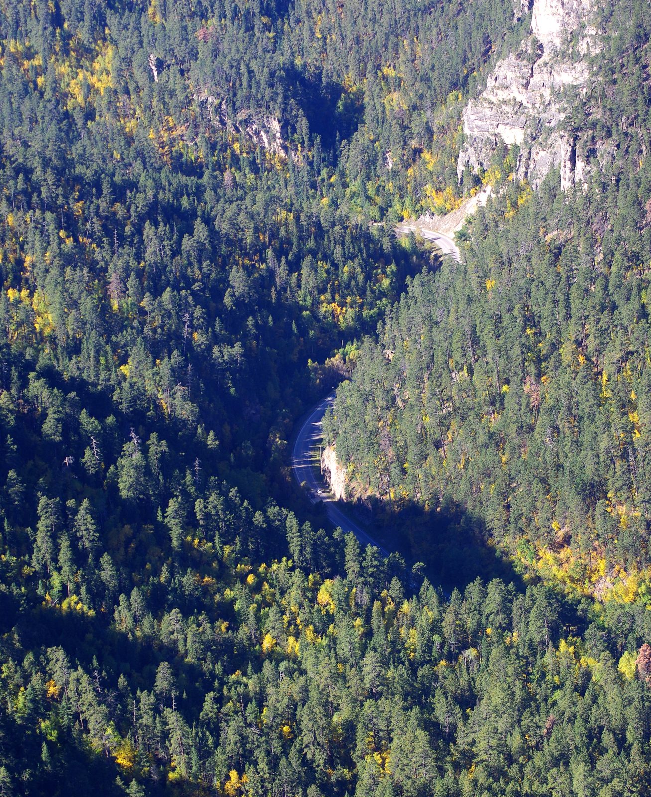
The railroad came first. The first trains ran in the canyon in 1893, a Forest Service sign at Bridal Veil Falls says, and Paul Higbee, in a 2019 South Dakota Magazine history of the line, has the first locomotive pulling into Spearfish that December. The sign credits the line to the Grand Island and Wyoming Central. It linked Spearfish, at the canyon's mouth, with the mining camps in the high country above its head, and the Forest Service counts Savoy and Elmore among its old stops. Stagecoaches and Railroads sets the canyon line beside the Hills' other railroads.
How Did the Creek Power the Homestake?
The Homestake ran Spearfish Creek through turbines in the canyon and sent the electricity to its mine at Lead. Its first hydroelectric plant went up in 1904, a mile from the canyon's mouth, according to the finding aid for its power plant records at the Homestake Adams Research and Cultural Center in Deadwood. To win water rights there, Homestake bought the Spearfish electric company and promised the town power. Distance was the problem. Sending that plant's electricity to Lead didn't pay, so in 1906 the company opened a larger plant nearer the mine. The creek's water was making the trip already: in 1909 Darton wrote that an aqueduct from Spearfish Creek supplied much of the water used by the gold mills at Lead.
The larger works followed. Hydroelectric No. 1, in the lower canyon near the fish hatchery, was built in 1909 and 1910, the finding aid says. To feed it, Homestake drove 23,862 feet of tunnels into the rock on the canyon's west side from 1909 to 1912, Higbee writes, and here the railroad and the power plants meet: canyon trains brought in the drills, crews and supplies, and surveyors used the rail bed as their reference in laying out the tunnels. The sources disagree on when the plant began running: a 2021 Black Hills Pioneer story puts its first power in 1911, while Spearfish's mayor told Congress in 2006 that it had run without a break since 1912. Hydroelectric No. 2, at Maurice higher in the canyon, was built from 1916 to 1918. Its water started at Savoy Pond; Game, Fish and Parks says the pond was built as the head of a 5-mile aqueduct feeding the Maurice Hydro Plant. No. 2 powered two Homestake hoists, the Golden Gate and the Old Brig. By 1925, the finding aid says, Homestake's own plants covered its whole demand for electricity, as The Homestake Mine and Sanford Lab also notes.
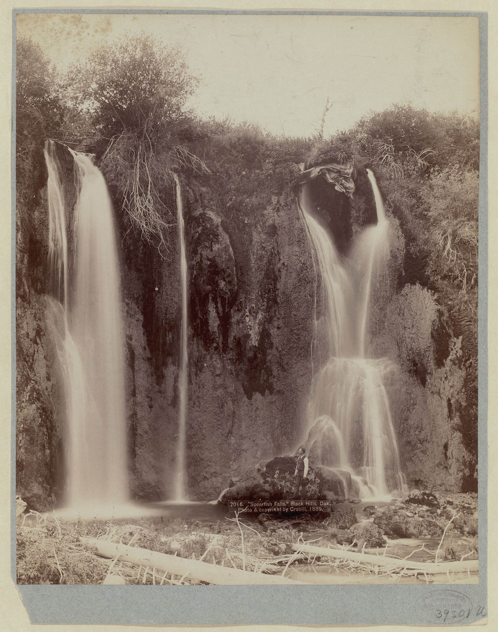
The same Forest Service sign says Homestake diverted the creek into flumes for its canyon power plants in 1879. That finding aid puts Homestake's first hydroelectric plant in 1904, so the sign's date doesn't fit the power plants. The creek, the canyon and the mine all lie west of the 103rd meridian, on land the 1868 treaty had set apart for the tribes and the 1877 Act took without the consent the treaty required (see The 1876 War and the Taking of the Hills).
The Flood of May 1933
One storm ended the canyon line. On May 22 and 23, 1933, a big storm system hit much of the Black Hills, the USGS records in its history of the area's floods. At Lead, 4.8 inches fell in 12 hours, and the agency notes severe flooding on Spearfish Creek. The line's last train ran on May 20, according to railroad records Higbee cites, and three days after that run the flooded creek tore out its bridges and track. That July the railroad chose not to rebuild and applied to the Interstate Commerce Commission to give the line up. The commission let it drop the 25 miles nearest Spearfish but required it to keep serving the mines around Bald Mountain, Higbee writes. The Forest Service sign calls the damage past repair. The sign says the track that was left was taken up in 1934 and 1935, as far as Portland, an old mining camp by Terry Peak.
A steady creek can still flood. Darton noted a reported flood of 4,150 cubic feet a second in June 1904, more than 40 times the average he gave for 1903 to 1906. The USGS history gives no peak flow for 1933, though, and neither it nor Higbee gives a cost or a death toll or says what the water did to Homestake's plants. The railroad's old grade now carries U.S. Highway 14A through Spearfish Canyon.
Who Runs the Creek's Power Plants Now?
The city of Spearfish runs the lower plant, and the Maurice plant has been shut since 2003. Homestake mined its last ore on December 14, 2001, and took Hydroelectric No. 2 out of service in October 2003, the finding aid says. The city bought No. 1 in 2004 from Homestake, which no longer had a mine to power, Jerry Krambeck, then the mayor, told House members in 2006.
Owning the plant brought a federal question. The Federal Energy Regulatory Commission had ruled in 2001 and 2002 that the plant, which had run on federal rights-of-way the commission found had expired, needed a license, Krambeck testified. Citing the commission's own studies, he said licensing even a small project could take more than six years, "at a cost that could approach millions of dollars." In June 2006 a House bill proposed exempting the plant and having the USGS study the creek instead. It also urged the city to leave about 5 to 10 more cubic feet a second in the creek between the Maurice Intake Dam and the Spearfish Diversion, as it had agreed with canyon landowners in 2004. The city applied for a license, and the commission issued one for the 4-megawatt plant in April 2011, Hydro Review reported.
As of August 2026 the plant was still generating, the Black Hills Pioneer reported during public tours that month. It draws from the creek upstream of town and pipes the water about 5 miles underground, around the stretch where the creek bed leaks into the aquifer below (see The Limestone Plateau and the Caves). The power that once went up to the mines at Lead now feeds the regional grid.
The Maurice plant went another way. Game, Fish and Parks acquired it from Homestake in 2014, along with Roughlock Falls and Spearfish Falls, South Dakota Searchlight reported in January 2026. That February Gov. Larry Rhoden signed a law, effective July 1, 2026, that lets the department hand the plant's 1917 building to a foundation at no cost, Searchlight reported. The title reverts to the state if the property goes two years running without a public use. Majority Leader Scott Odenbach, a Spearfish Republican who backed the bill, called the building a "time capsule" that January, and it could become an interpretive center. Upstream at Savoy, the Savoy Trail follows the corridor of the old aqueduct to Savoy Pond, the Forest Service says.
Connected
- Spearfish CanyonThe canyon the creek cut, with the byway on the old rail grade and the trail to Savoy Pond.
- The Homestake Mine and Sanford LabThe mine the canyon plants powered, from the 1876 claim to the physics lab.
- Stagecoaches and RailroadsThe canyon line among the Hills' railroads, and its rails pulled up after the flood.
- Spearfish, South DakotaThe town at the canyon's mouth that bought Homestake's lower power plant in 2004.
- Lead, South DakotaThe company town whose mine took the creek's water and power.
- The Limestone Plateau and the CavesThe limestone that swallows part of the creek, and the stretch its water is piped around.
- The 1876 War and the Taking of the HillsHow the land along the creek was taken from the tribes.
Sources
- Geology and Water Resources of the Northern Portion of the Black Hills and Adjoining Regions in South Dakota and Wyoming (Professional Paper 65), water resources section, by N.H. Darton. U.S. Geological Survey, 1909 (online edition, NPS History).
- Spearfish Canyon Through Time (marker text). Black Hills National Forest, U.S. Forest Service; transcribed by the Historical Marker Database, 2018.
- Spearfish Canyon. USDA Forest Service, Black Hills National Forest.
- Hydroelectric and Kirk Power Plant Operation Records, finding aid. Homestake Adams Research and Cultural Center (Deadwood History), 2023.
- Rocky Road, by Paul Higbee. South Dakota Magazine, 2019 (revised online, 2023).
- Hydro History, by Alex Portal. Black Hills Pioneer, 2021.
- Spearfish Canyon Nature Area (trail map). South Dakota Game, Fish and Parks, undated.
- Black Hills Area Floods: 1931 to 1940. U.S. Geological Survey, Dakota Water Science Center, 2017.
- Testimony of Jerry Krambeck, Mayor of Spearfish, on H.R. 5566. House Committee on Resources, Subcommittee on Water and Power, 2006.
- H.R. 5566, a bill to facilitate the transfer of Spearfish Hydroelectric Plant Number 1 to the city of Spearfish, South Dakota (as introduced). U.S. House of Representatives, 109th Congress (GovInfo), 2006.
- City of Spearfish, South Dakota; Notice of Availability of Draft Environmental Assessment (Project No. 12775-001). Federal Energy Regulatory Commission, Federal Register, 2010.
- FERC Licenses Two Projects, Takes Applications for Four in April. Hydro Review (Renewable Energy World), 2011.
- Hydro Plant Opens for Spearfish Creek Watershed Festival Tours, by Sierra Ferguson. Black Hills Pioneer, 2026.
- Former Homestake Mine Hydro Plant in Spearfish Canyon Could Become an Interpretive Center, by Joshua Haiar. South Dakota Searchlight, 2026.
- Transfer of Spearfish Canyon Hydro Plant and Funding for Fish Hatchery Earn Governor's Approval. South Dakota Searchlight, 2026.
- House Bill 1052 (enrolled): An Act to authorize the transfer of certain surplus real property by the Department of Game, Fish and Parks to the Spearfish Canyon Foundation for a public purpose. South Dakota Legislature, 2026.
- Savoy Trail (project page). USDA Forest Service, Black Hills National Forest, 2017.
Last reviewed: