Towns
Box Elder, South Dakota
Most of Ellsworth Air Force Base stands on gravel. Older streams left it in broad benches that sit higher than today's creek bottoms, and a U.S. Geological Survey study published in 2022 places those terrace deposits under most of the base. Box Elder grew up beside it, just east of Rapid City, in Pennington and Meade counties. The city had 11,746 people in the 2020 census, more than four times as many as in 1990. Its story runs from that ground and a 1907 railroad stop to the air base next door and the new bomber on its way.
Prairie Ground East of the Hogback
Box Elder lies outside all four rings of rock described on How the Black Hills Formed. The outermost ring, the sandstone ridge called the Hogback, runs through Rapid City to the west, and the open prairie begins east of it (see The Central Hills). Under that prairie is the Pierre Shale, the dark gray rock that floors the plains north and east of the Hills, described on Bear Butte and the Plains Edge. It formed on the bed of a shallow inland sea, the Western Interior Seaway. Where the shale shows at the base of the Badlands, the National Park Service dates it to about 75 to 69 million years ago.
Near Box Elder the shale is mostly covered. The 2022 USGS study, which mapped the buried top of the shale east and southeast of the base, describes two kinds of loose ground on it. Mud, silt, sand and gravel line the active streams. The terrace deposits are older, left by earlier rivers, and lie higher. They can reach about 100 feet thick, though drillers' logs put their average nearer 33 feet, and they thin out to the south and east, away from the Hills. In some places the shale lies bare at the surface. Rain and streams recharge the gravel, which holds shallow groundwater moving generally southeast, toward Box Elder Creek.
The result is ground that comes in steps: the higher gravel benches that carry most of the base, and the lower, younger ground along the streams.
The creek, which the USGS writes as Boxelder Creek, comes out of the Hills past Nemo and reaches the plains short of water. Crossing the limestone and other layers of the eastern flank, between gauges near Nemo and Rapid City, it meets rock that can take in about 50 cubic feet of water a second, more than half of it into the Madison Limestone, a 1998 USGS study found. At the study's measuring site below that stretch, the creek was dry on every measuring date but two, and it ran through for long spells only in a few high-water years of the 1980s and 1990s. Where that lost water goes is followed on The Limestone Plateau and the Caves.
A Railroad Stop That Took a Creek's Name
The 1868 Fort Laramie Treaty set this prairie inside the Great Sioux Reservation, and the 1877 Act took it, with the Hills, without the consent the treaty required (see The 1876 War and the Taking of the Hills). Travelers on the stage and wagon road from Fort Pierre into the Hills rested in the valley in the late 1800s, Box Elder's mayor, Larry Larson, said in a 2024 SDPB feature, but the town waited for the railroad.
The railroad came in 1907, when the Chicago and North Western Railway pushed on to Rapid City, running out from Pierre by way of Philip and Wall, according to a Park Service history of the Badlands. In Larson's account a general store beside Box Elder Creek became the line's stop between Wasta and Rapid City, and the first post office opened inside it; the State Historical Society's list of South Dakota towns dates that post office to June 22, 1907. The settlement took the creek's name. The English name translates an earlier tribal name for the stream, chosen, Larson said, for the box elder trees that were plentiful along it. The same state list dates Box Elder's incorporation as a city to May 12, 1965; Larson gave September 29, 1964.
The Census Bureau counted about 2,700 people in Box Elder in 1990, as South Dakota News Watch reported, then 7,800 in 2010 and 11,746 in 2020.
Is Ellsworth Air Force Base in Box Elder?
It is next door, though the city calls itself home to the base. The USGS describes the base as adjacent to Box Elder, and the city's population figures leave out people living on the base; South Dakota News Watch, for its part, placed the base in Box Elder in 2024.
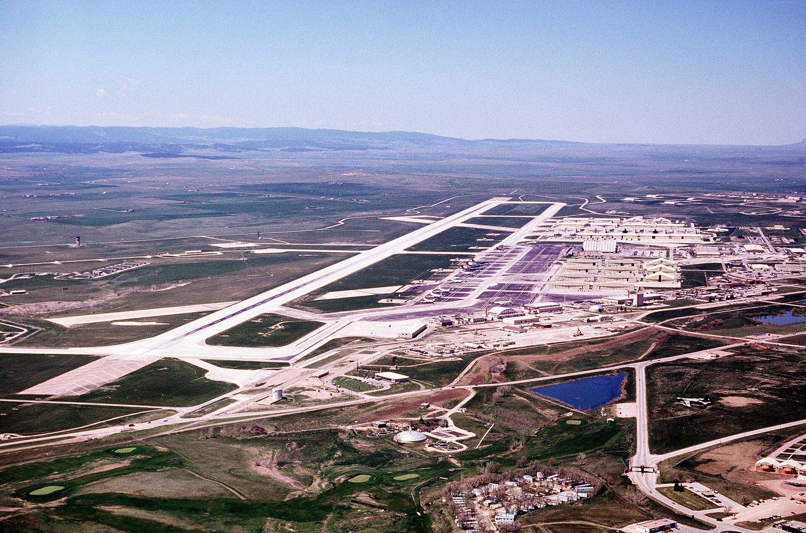
The base dates from January 1942. That month the War Department set up a training field on open ground just east of Rapid City, where B-17 Flying Fortress crews prepared for the war in Europe, SDPB's history of the base recounts. First called Rapid City Army Air Base, it was renamed for Brig. Gen. Richard E. Ellsworth, commander of the 28th Strategic Reconnaissance Wing, who was killed in a crash in Newfoundland in March 1953. President Dwight D. Eisenhower came that June to dedicate the base in his memory. Its bombers, from the B-29 to the B-1B, and the Minuteman missile field it ran across western South Dakota are traced on Ellsworth and the Minuteman Missiles.
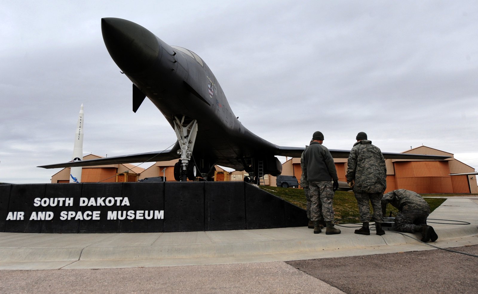
In Box Elder, by the base's main gate, the Air Force keeps a field museum, the South Dakota Air and Space Museum. The Park Service lists a B-29, a B-52 and a B-1 in its collection, along with a Titan I missile and a Minuteman. Its indoor galleries reopened in June 2024 after two years closed, and 33 aircraft are on display outside, the base reported.
The B-21 and a Growing City
In June 2021 the Air Force made Ellsworth the first main operating base for the B-21 Raider, a stealth bomber, and the home of its training unit, Dakota News Now reported. The first B-21 is to arrive in 2027, a little earlier than first planned, Air & Space Forces Magazine reported in June 2026 after interviewing Air Force Secretary Troy Meink. The B-21s are to replace the B-1s.
Box Elder has been growing ahead of it. Col. Derek Oakley, commander of the 28th Bomb Wing, expected the B-21 program to add more than 4,000 people at the base over two decades, counting service members, their families and civilian workers, South Dakota News Watch reported in July 2024. Box Elder's public information officer told KOTA in February 2024 that the city had already passed the 13,000 residents its 2022 housing study expected by 2026, not counting people on the base, and that the bigger wave of airmen had not yet arrived.
The base is not the whole story, the city says. In April 2025 Sean Overeynder, Box Elder's director of community and economic development, told KOTA that Ellsworth's expansion drives demand for homes and businesses but is one factor among several, along with the strength of the regional economy, the town's access to Interstate 90, rising traffic and tourism.
Rapid City, the Badlands and the Plains Edge
The city government describes Box Elder as adjacent to Rapid City, which grew where Rapid Creek cuts through the Hogback. Interstate 90 runs through Box Elder, west into Rapid City and east across the prairie toward Wall and the Badlands (see The Badlands and Wall). Farther north along the same plains edge, Bear Butte, a mountain many tribes hold sacred, rises about 6 miles northeast of Sturgis.
The base's Cold War years also tie Box Elder to the far end of the Hills, where a uranium mill at Edgemont ran from 1956 to 1972. That thread is followed on Uranium, the Cold War and the Missiles.
Connected
- The Central HillsThe region whose eastern foot takes in Rapid City and Box Elder.
- Ellsworth and the Minuteman MissilesThe 1942 air base beside Box Elder, its bombers and its missile field.
- Uranium, the Cold War and the MissilesThe Cold War thread from Edgemont's uranium to Ellsworth's missiles.
- Rapid City, South DakotaThe city next door, built across the Hogback where Rapid Creek leaves the Hills.
- How the Black Hills FormedThe four rings of rock that end west of Box Elder.
- Bear Butte and the Plains EdgeThe Pierre Shale prairie that rings the Hills, Box Elder's ground.
- The Badlands and WallThe country east along Interstate 90 from Box Elder.
- The 1876 War and the Taking of the HillsHow the 1877 Act took the prairie around Box Elder with the Hills.
Sources
- Delineating the Pierre Shale from Geophysical Surveys East and Southeast of Ellsworth Air Force Base, South Dakota, 2021 (Scientific Investigations Map 3497), by C.J. Medler. U.S. Geological Survey, 2022.
- Scientific Investigations Map 3497, sheet 1. U.S. Geological Survey, 2022.
- Geologic Formations of Badlands National Park. National Park Service.
- Streamflow Losses in the Black Hills of Western South Dakota (Water-Resources Investigations Report 98-4116). U.S. Geological Survey, 1998; Boxelder Creek section in pages 48 to 99.
- Origins of Box Elder, South Dakota, by Kylin McKean. Dakota Life, SDPB, 2024.
- History of Badlands National Monument and the White River (Big) Badlands of South Dakota: The Settlers Come. National Park Service (online edition, NPS History), updated 2009.
- SD Towns (South Dakota towns, with post office and incorporation dates). South Dakota State Historical Society, State Archives, 2010.
- QuickFacts: Box Elder city, South Dakota. U.S. Census Bureau.
- Harrisburg, Tea, Box Elder Lead Booming South Dakota Cities, by Mariia Novoselia. South Dakota News Watch, 2024.
- Community Profile. City of Box Elder.
- A History of the Ellsworth Air Force Base. SDPB, 2023.
- South Dakota Air and Space Museum. National Park Service, 2025.
- Ellsworth Celebrates South Dakota Air and Space Museum Reopening, by Brittany Kenney. 28th Bomb Wing Public Affairs, U.S. Air Force, 2024.
- South Dakota's Ellsworth Air Force Base to Be First Home for B-21 Bomber, by Ernest Cottier. Dakota News Now, 2021.
- Air Force Accelerates Sending B-21s to Ellsworth, by Stephen Losey and Courtney Albon. Air & Space Forces Magazine, 2026.
- Box Elder Passes Housing Study Projected Population Growth, Continuing to Focus on Healthy City Development, by Humberto Giles-Sanchez. KOTA, 2024.
- Box Elder Sees Economic Growth in the Midst of Ellsworth Expansion, by Hannah Hutter. KOTA, 2025.
Last reviewed: