Regions
The Badlands and Wall
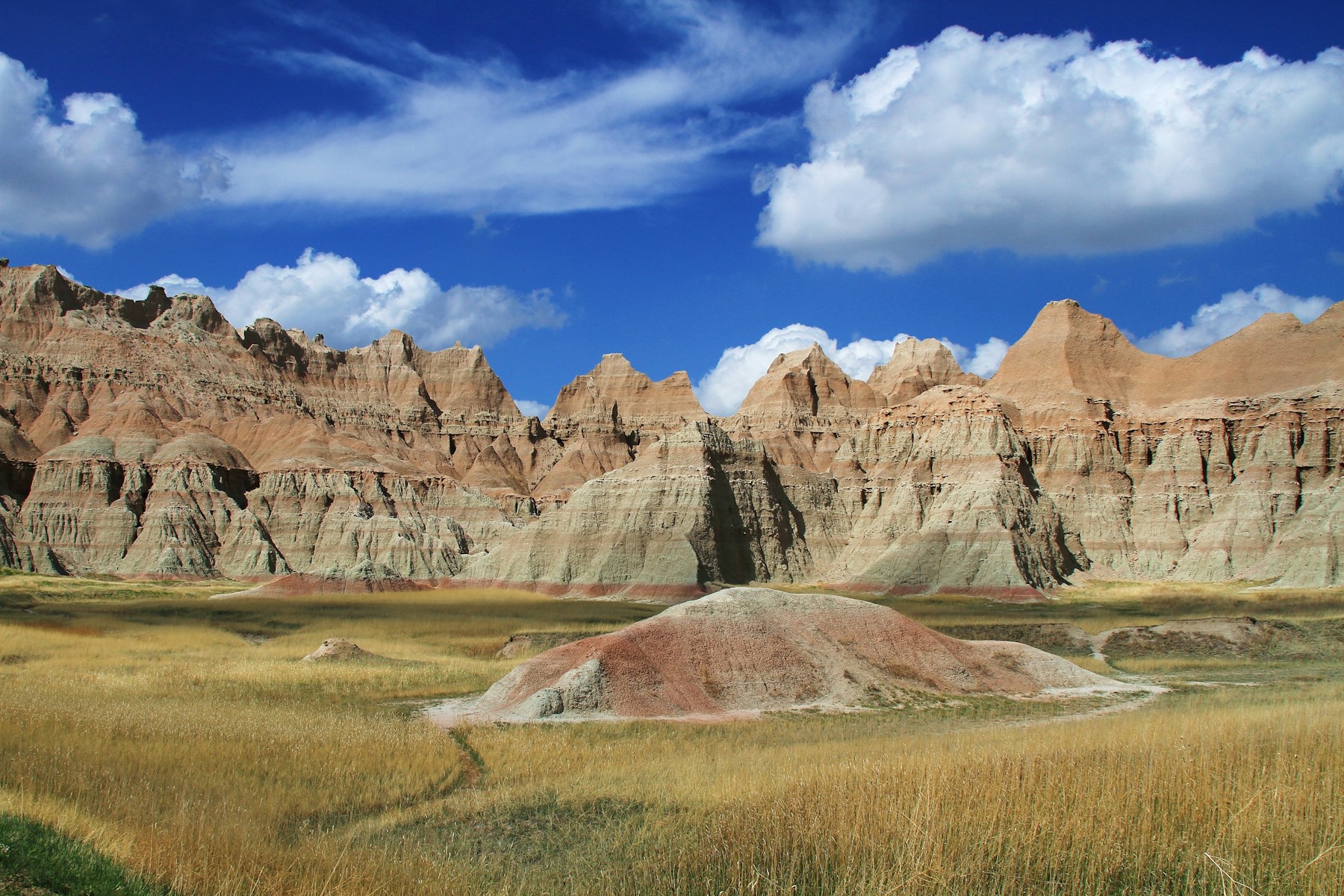
A line of eroded cliffs called the Badlands Wall follows the north side of the White River valley, starting near Kadoka and ending at the edge of the town that carries its name. Above the cliffs lies an upper prairie. Below them the ground drops to a lower one, and badlands of buttes, gullies and tables crowd both sides of the valley. This is the country east of the Black Hills along Interstate 90 and the White River: Badlands National Park, with its North and South Units; the towns of Wall and Interior; the ghost town of Scenic; and the eastern side of the Buffalo Gap National Grassland.
Past the Last Ring of Rock
Badlands National Park lies about 75 miles east of Rapid City, the Park Service says, far beyond the Hogback, the outermost of the four rings of rock described on How the Black Hills Formed. Its rock is younger than any of those rings: layers laid down from roughly 75 million to 28 million years ago, from the Pierre Shale, once mud on the bottom of an inland sea, to the Sharps Formation on top. The cover out here is mixed-grass prairie, not the pine forest of the Hills.
Water did the carving. The Park Service credits the White and Cheyenne Rivers with cutting the landscape and estimates that the buttes lose about an inch a year; scientists, it adds, expect the Badlands to be worn away entirely in another 500,000 years. How the Badlands Erode explains why the layers fall apart so easily, and Fossils and the Mammoth Site covers the ammonites, mosasaurs, brontotheres and oreodonts that the erosion keeps uncovering.
Wall, Interior and the Loop Road
Wall counted 699 people in the 2020 Census. The Chicago and North Western laid track through it in 1907, on a line between Pierre and Rapid City. Wall Drug began as a country pharmacy: Ted and Dorothy Hustead bought it in December 1931, and in the hot summer of 1936, on Dorothy's idea, Ted put up roadside signs offering drivers free ice water. The Dust Bowl, Free Ice Water and the Highway follows what came of those signs.
Exit 110 at Wall and Exit 131 farther east both lead to the Badlands Loop Road, South Dakota Highway 240, which crosses the North Unit between the Pinnacles and Northeast Entrances, past a string of overlooks and the Ben Reifel Visitor Center. At Exit 116, 6 miles east of Wall, a glass shelter covers the partly open silo of Delta-09, where a deactivated training missile rests. It is part of Minuteman Missile National Historic Site, and Ellsworth and the Minuteman Missiles tells the missile field's story.
Interior, home to 65 people in 2020, sits in the White River valley on Highway 44, a 2-mile drive south of the park's Interior Entrance. The town began about 1881 as Black, a settlement a couple of miles to the southeast. It became Interior about 1895, by a 1968 history of the Badlands, and moved to its present site in 1907, when the Milwaukee Road laid its tracks along the White River.
West on Highway 44, at the western edge of the Badlands, is Scenic. It once had a bank, a hotel and a school, and its population peaked at 155 in 1915, according to State Historical Society records cited by the Associated Press. By 2011 its buildings were padlocked and boarded, and that year the Iglesia ni Cristo, a church founded in the Philippines in 1914, bought 46 acres, deserted town included, for under $800,000.
Who Owns the South Unit?
The South Unit of Badlands National Park is Oglala Sioux Tribe land. Its roughly 133,000 acres, a little more than half of the park's 244,000, lie entirely within the Pine Ridge Reservation. The land is held in trust for the Oglala Sioux Tribe and run by the National Park Service under a 1976 agreement with the tribe.
For Lakota families, the park's southern half began with a loss. During World War II the War Department turned 341,726 acres of the reservation into an aerial gunnery range, taking the land in 1942. The range pushed 125 families off their land, and most Lakota residents had just 10 days' notice. "It really was a sad time for these people that lost lands there," Emma Featherman-Sam, an Oglala Lakota who was the first director of the tribe's Badlands Bombing Range Project, said in a 2023 article published by the Smithsonian. Shells from the range struck a church in Interior. When most of the range was declared excess in 1968, Congress returned the bulk of it to the tribe, on the condition that the Park Service run the part that became the South Unit. Unexploded ordnance still lies in the unit, the Park Service warns; the tribe started the Bombing Range Project in 1993 to find and chart it.
A 2012 federal plan recommended making the unit the first tribal national park, a step that would need an act of Congress. Congress has not created one, and in 2015 the tribal council voted to end its part in that effort. "We want the National Park Service off our reservation," council member Chancy Wilson said that year. As of October 2026, the Park Service describes the unit as managed with the tribe. Stronghold Table, inside the unit, is believed to be where the 19th century's last Ghost Dance was held, according to the Park Service; the Ghost Dance and the massacre that followed are told on Wounded Knee.
Grass, Claims and Ferrets on the Buffalo Gap
The Buffalo Gap National Grassland covers almost 600,000 acres, from Kadoka to the corner where South Dakota, Nebraska and Wyoming meet. Its east side is run from the Forest Service's Wall Ranger District, whose office in Wall stands beside the National Grasslands Visitor Center.
Homesteaders reached this country just ahead of the railroads. By the fall of 1906, according to Leonel Jensen, a longtime resident cited in a Park Service history, practically every quarter section had a claim shack on it. The fate of those claims, and the grassland that grew out of them, is told on Homesteading the Edges of the Hills.
Black-footed ferrets live in the prairie dog towns here. A 1994 federal decision approved returning them to Badlands National Park and the Buffalo Gap grassland, with the first releases to be made in the park. In July 2026, as the Forest Service and the town of Wall got ready to celebrate three decades of ferret releases in the region, biologist Travis Livieri told South Dakota Public Broadcasting that the Conata Basin and Badlands population, 250 ferrets in 2024, had fallen below 100 after the 2025 drought. Prairie Dogs and Black-Footed Ferrets follows the animals.
Connected
- Wall, South DakotaThe town at the western end of the Badlands Wall, off Exit 110.
- Interior, South DakotaThe old Milwaukee Road town in the White River valley.
- Badlands National ParkVisiting the park's North and South Units.
- How the Badlands ErodeThe soft layers and the rivers that carve them.
- Scenic, South DakotaThe ghost town on Highway 44 at the western edge of the Badlands.
- Ellsworth and the Minuteman MissilesThe wartime air base, the missile field and the historic site east of Wall.
- How the Black Hills FormedThe four rings of rock that end long before the Badlands begin.
- Fossils and the Mammoth SiteThe sea reptiles and early mammals that erosion uncovers here.
- Homesteading the Edges of the HillsThe claims filed on these plains and how the Buffalo Gap grassland came out of them.
- The Dust Bowl, Free Ice Water and the HighwayHow a Wall drugstore drew drivers off the road.
- Prairie Dogs and Black-Footed FerretsThe ferrets returned to the park and the grassland.
- Wounded KneeThe Ghost Dance, tied to Stronghold Table, and the 1890 massacre.
Sources
- Badlands Wall. National Park Service, Badlands National Park, 2020.
- Geologic Formations: How Badlands Buttes Came to Be. National Park Service, Badlands National Park, 2020.
- Nature. National Park Service, Badlands National Park, 2020.
- Directions. National Park Service, Badlands National Park, 2020.
- Drive the Badlands Loop Road (Highway 240). National Park Service, Badlands National Park, 2020.
- History of Badlands National Monument and the White River (Big) Badlands of South Dakota: The Settlers Come. Badlands Natural History Association, 1968; copy held by the NPS History Collection.
- TIGERweb, 2020 Census incorporated places. U.S. Census Bureau, 2020.
- Wall Drug, by Sheila R. Aaker. Encyclopedia of the Great Plains, University of Nebraska–Lincoln.
- The early days of Wall Drug, by Brian Gevik. South Dakota Public Broadcasting, 2015.
- Delta-09. National Park Service, Minuteman Missile National Historic Site.
- Church won't say boo on plans for ghost town, by Amber Hunt (Associated Press). Honolulu Star-Advertiser, 2011.
- Stronghold District. National Park Service, Badlands National Park, 2020.
- Aerial Gunnery Range. National Park Service, Badlands National Park, 2020.
- On Dangerous Ground: Oglala Lakota Land Used as a Bombing Range in World War II Is Still Perilous, by William C. Meadows. American Indian magazine, Smithsonian National Museum of the American Indian, 2023.
- Salazar, Jarvis Announce Proposal to Establish Nation's First Tribal National Park in Badlands. U.S. Department of the Interior, 2012.
- Will the Badlands become the first tribal national park?, by Brendan Borrell. High Country News, 2013.
- Dream of tribal national park in South Dakota crumbling (Associated Press). Mitchell Republic, 2015.
- Buffalo Gap National Grassland. USDA Forest Service, Nebraska National Forests and Grasslands.
- Wall Ranger District. USDA Forest Service, Nebraska National Forests and Grasslands.
- Record of Decision, Final Environmental Impact Statement, Black-Footed Ferret Reintroduction, Conata Basin/Badlands, South Dakota. National Park Service, Federal Register 59, no. 118, 1994.
- Forest Service, community of Wall celebrating black-footed ferret reintroduction. South Dakota Public Broadcasting, 2026.
- Scientists celebrate a milestone for the critically endangered black-footed ferret, by Lori Walsh. South Dakota Public Broadcasting, 2026.
Last reviewed: