Ranching, Farming and Work
Homesteading the Edges of the Hills
In 1911 the rain gauge at the federal experiment farm at Newell, on the plains about 30 miles northeast of the Black Hills, caught 6.64 inches all year. Wheat on the farm's dryland plots failed that summer and again in 1912. Records kept there from 1908 through 1919 averaged 14.31 inches a year, and in 1922 a federal agronomist reported that most homesteads in the surrounding region had been given up after a string of dry years. Homesteading on the plains around the Hills ran on federal land laws, from the 1862 act to the bigger claims of 1909 and 1916, and on rain, soil and grass that decided who left and who stayed.
What the Homestead Laws Offered
The Homestead Act gave up to 160 acres of surveyed public land, a quarter section, to a settler who would live on it and farm it for five years. Approved on May 20, 1862, it took effect on January 1, 1863. A claimant had to be 21 or a family head, a citizen or on record as intending to become one, and never have fought against the United States. The filing fee was $10. Or, after six months, a settler could buy the claim at $1.25 an acre.
Meeting the terms and getting the deed was proving up. About 40 percent of homesteaders got that far, says a National Park Service article on Badlands homesteading, which doesn't say where the figure applies. Over the life of the Homestead Act, homesteaders received more than 270 million acres in 30 states. Free land was a smaller share of what the government parted with than legend has it: homesteaders got 80 million of the roughly 500 million acres the General Land Office disposed of from 1862 to 1904, the National Archives says.
Later laws enlarged the claim for dry country. The Enlarged Homestead Act of February 19, 1909, allowed up to 320 acres on land the Secretary of the Interior had ruled out for irrigation at a reasonable cost. Wyoming was among the seven states and two territories it first named; South Dakota was not. In a 1954 South Dakota State College pamphlet, Ray Pengra and Gabriel Lundy wrote that the limit in western South Dakota did later rise to 320 acres, still too little. In 1912 Congress cut the residence requirement to three years. The Stock-Raising Homestead Act of December 29, 1916, allowed up to 640 acres of grazing land, the amount the law called "reasonably required for the support of a family," but kept the coal and other minerals for the United States. In 1983 the Supreme Court put the land patented under it at more than 33 million acres.
Gumbo, Grass and 14 Inches of Rain
The plains around the Hills grew grass far more dependably than grain. The Newell farm sat on gumbo, which the Bureau of Soils mapped as Pierre clay: roughly a third clay and two-fifths silt. After a rain it went to glue that water barely soaked into, and no plow could work it until it dried. Western wheatgrass and buffalo grass made up most of the unplowed sod. The wettest year in the farm's records, 1915, brought 21.02 inches, more than three times the 1911 total. The Natural Resources Conservation Service's Pierre Shale Plains region, about 70 percent of it in South Dakota, has clay soils, gets 13 to 16 inches a year on its western side, and is used mainly for ranching.
John H. Martin, the agronomist who wrote up the Newell cereal trials, concluded in a 1922 Agriculture Department bulletin: "Grain growing alone is not likely to be successful in western South Dakota." Grain raised alongside livestock, he judged, would pay in some years. Along the rim of the Hills and inside them, he reported, dry farming still paid. The 160-acre limit, Pengra and Lundy noted, came from experience in wetter states and fell far short here. In 1900, before the rush, about 4,800 farms and ranches were spread across the nearly 25 million acres west of the Missouri, and most ranch headquarters stood beside a stream or spring.
Water made one valley different. The Belle Fourche Project, approved on May 10, 1904, finished Orman Dam on June 30, 1911, and its canals brought water to farms around Newell. Part of the Newell farm went under irrigation in 1912. The project is told on The Belle Fourche Irrigation Project, and its town on Newell, South Dakota.
From Cattle Range to Homestead Claims
Before the homesteaders, the plains were cattle range. The winter of 1886–87 killed thousands of cattle across Wyoming; historians generally think the loss figures run high, Samuel Western wrote in 2014. That winter is told on The Winter of 1886–87 on the Cattle Range.
In South Dakota nearly all of this country had been inside the Great Sioux Reservation set apart by the 1868 treaty: the 1877 Act took the Hills and the land west of the 103rd meridian without the consent the treaty required, and the Act of March 2, 1889 cut about 9.3 million acres more from the reservation and opened them to settlement.
The rush came after 1900. Homestead filings in western South Dakota came in great numbers in 1907 and 1908, and homesteading there was at its peak by the 1910 census, Pengra and Lundy found. More than 100,000 settlers moved into the West River country between 1900 and 1915, according to the publisher's summary of historian Paula M. Nelson's 1996 book and Jean Choate's 1998 review of it.
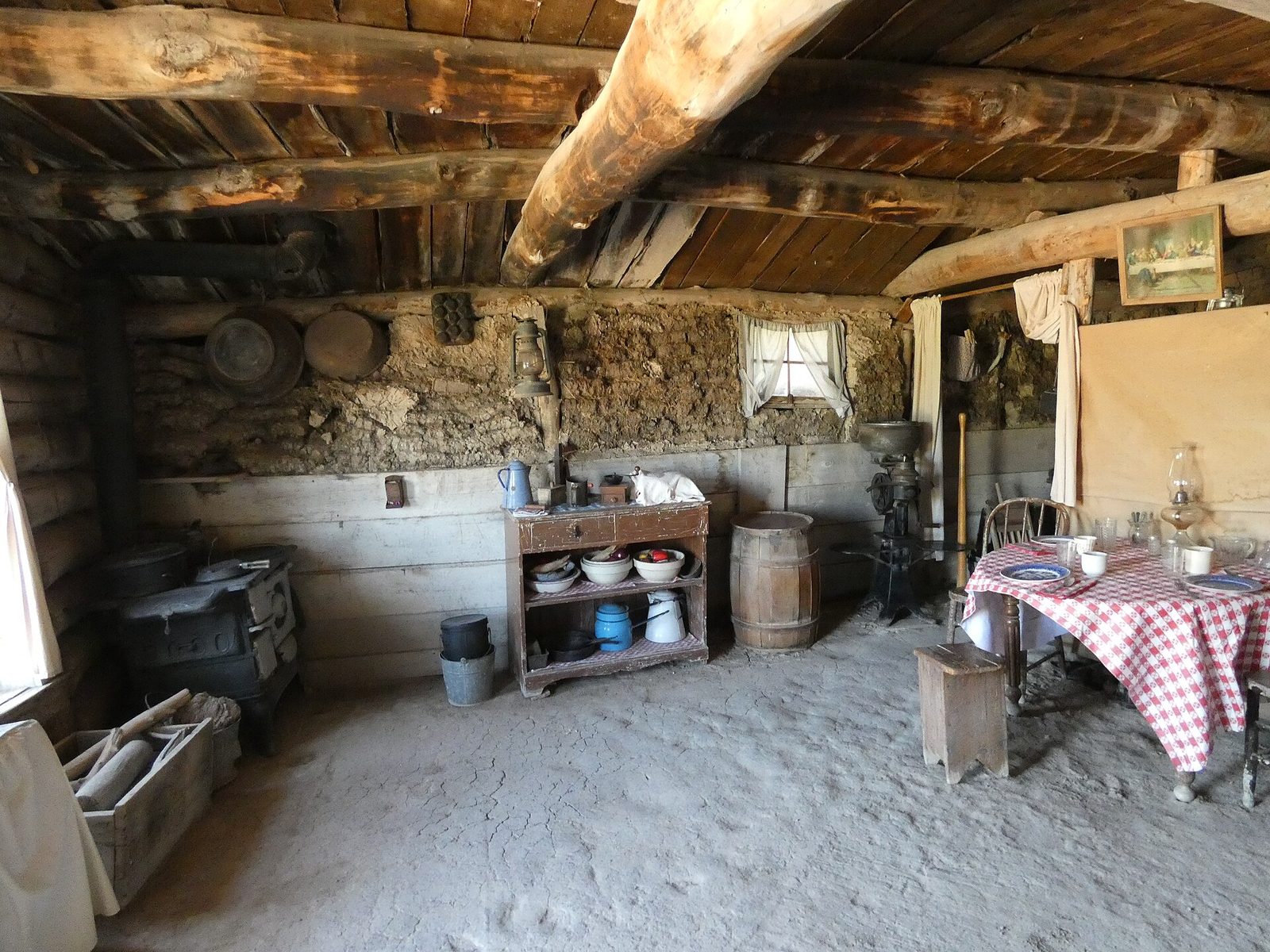
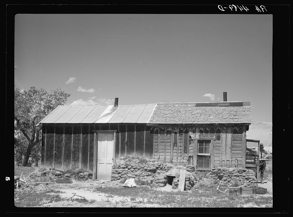
Proving Up in an 8-by-10 Shanty
Martha Stoecker filed in November 1904 on a quarter section in Stanley County, about 15 miles from Hayes, at the Missouri River end of the West River plains and well east of the Hills. Her memoir, edited by Glenda Riley for South Dakota History in 1986, describes a shanty ordered at 9 by 12 feet and built at 8 by 10, for $12.50 in lumber, hauling and labor. To prove up she had to live there, cultivate at least 10 acres and pay 50 cents an acre. She also taught the new school at Hayes, for $40 a month. When she moved onto the claim alone in the spring of 1906, she recalled, no other single women had claims nearby. In the 1911 drought, Riley's closing note adds, the ground split in deep cracks; the seed Martha and her husband, Albert Norby, had planted never sprouted, and they moved to Fort Pierre.
Widows, divorced women and single women could all file; a wife, at first, only if her husband had deserted her. Counts of women homesteaders differ. Greg Bradsher, a National Archives archivist, wrote in 2021 that women were under 10 percent of homesteaders before 1900 and an estimated 10 to 15 percent in the early 1900s in some states, the Dakotas and Wyoming among them. Riley cites an older estimate that women held as many as a third of Dakota homesteads by 1887.
Who Failed and Who Stayed?
Dry years did most of the sorting. Many speculators, and many settlers with little staying power, gave up in the drought of 1910 and 1911, the same summary of Nelson's book says, and Pengra and Lundy found that many left after the poor rains of 1911.
The 1930s were worse. Farm prices fell, and grasshoppers and dust storms came with the drought. Preliminary 1940 census figures showed 61 of South Dakota's 69 counties losing people over the decade, 51,715 in all, and an estimate in a 1940 state pamphlet put the loss from farms at 82,631. The federal government labeled 13 West River counties "submarginal," Choate writes, and set up programs to move their families elsewhere. Farms kept going under to foreclosure, families kept leaving for Oregon, Washington and California, and county agents pressed farmers to switch to ranching.
The government bought 11.3 million acres of submarginal land in 11 states, for an average of $4.40 an acre. When 19 national grasslands were designated on June 20, 1960, 3.8 million of those acres went into them, including Thunder Basin in Wyoming and the Buffalo Gap National Grassland in South Dakota, which, at almost 600,000 acres, now extends from Kadoka to the point where South Dakota meets Nebraska and Wyoming.
The Buffalo Gap grassland is run from two ranger districts, one based in Hot Springs and one in Wall, where the National Grasslands Visitor Center stands next to the district office. The country around Wall is on The Badlands and Wall.
In Choate's telling, the families who held on took the "submarginal" label as an insult: they had always seen themselves as builders, and the New Deal cast the pioneer as a destroyer. In Nelson's account, success on these plains came to mean simply surviving, after drought upon drought had cut people's ambitions down. Many homesteaders who stayed began families that have farmed and ranched the same land for generations, the Park Service notes.
Connected
- The Belle Fourche Irrigation ProjectThe 1904 reclamation project that watered one valley while the plains around it stayed dry.
- Newell, South DakotaThe irrigation-project town and home of the experiment farm that measured the rain.
- The Winter of 1886–87 on the Cattle RangeThe hard winter on the cattle range, two decades before the homestead rush.
- The Open Range and the Cattle DrivesThe cattle years on the same plains before the claims were filed.
- The 1876 War and the Taking of the HillsHow the Hills and the land around them were taken from the tribes.
- The Badlands and WallThe country around Wall, where part of the Buffalo Gap National Grassland is managed.
Sources
- Homestead Act (1862), Milestone Documents. National Archives.
- Homesteading. National Park Service, Badlands National Park, 2020.
- Frequently Asked Questions. National Park Service, Homestead National Historical Park.
- An Act to Provide for an Enlarged Homestead (Act of February 19, 1909, 35 Stat. 639). United States Statutes at Large, 1909 (GovInfo, US Government Publishing Office).
- An Act to Amend Sections 2291 and 2297 of the Revised Statutes Relating to Homesteads (Act of June 6, 1912, 37 Stat. 123). United States Statutes at Large, 1912 (GovInfo, US Government Publishing Office).
- An Act to Provide for Stock-Raising Homesteads (Act of December 29, 1916, 39 Stat. 862). United States Statutes at Large, 1916 (GovInfo, US Government Publishing Office).
- Watt v. Western Nuclear, Inc., 462 U.S. 36. Supreme Court of the United States, 1983 (Legal Information Institute, Cornell Law School).
- Experiments with Cereals on the Belle Fourche Experiment Farm, Newell, S. Dak., by John H. Martin. US Department of Agriculture Bulletin 1039, 1922 (Internet Archive).
- Ecological Site Description R060AY041SD, Loamy 16-18" P.Z., MLRA 60A Pierre Shale Plains. USDA Natural Resources Conservation Service, 2024.
- Fifty Years of South Dakota Agriculture, by Ray F. Pengra and Gabriel Lundy. Agricultural Economics Pamphlet 56, South Dakota Agricultural Experiment Station, South Dakota State College, 1954.
- The Prairie Winnows Out Its Own: The West River Country of South Dakota in the Years of Depression and Dust, by Paula M. Nelson (book description). University of Iowa Press, 1996 (Project MUSE).
- Review of The Prairie Winnows Out Its Own, by Jean Choate. Great Plains Quarterly 18, no. 1, 1998.
- West River Country, by Paula M. Nelson. Encyclopedia of the Great Plains, University of Nebraska–Lincoln.
- Population Changes in South Dakota, by Vera Petheram and W. F. Kumlien. Rural Sociology Pamphlet 1, South Dakota Agricultural Experiment Station, 1940.
- National Grasslands, by Francis Moul. Encyclopedia of the Great Plains, University of Nebraska–Lincoln.
- More Than Meets the Eye, by Michelle Putz. USDA Forest Service, 2024.
- Buffalo Gap National Grassland. USDA Forest Service, Nebraska National Forests and Grasslands.
- Wall Ranger District. USDA Forest Service, Nebraska National Forests and Grasslands.
- The Sioux Agreement of 1889 and Its Aftermath, by Herbert T. Hoover. South Dakota History 19, no. 1, South Dakota State Historical Society, 1989.
- An Act to Divide a Portion of the Reservation of the Sioux Nation of Indians in Dakota into Separate Reservations (Act of March 2, 1889, 25 Stat. 888). United States Statutes at Large, 1889 (GovInfo, US Government Publishing Office).
- Proving Up: The Memoir of "Girl Homesteader" Martha Stoecker Norby, edited by Glenda Riley. South Dakota History 16, no. 1, South Dakota State Historical Society, 1986.
- Women Homesteaders, by Greg Bradsher. The Text Message, National Archives, 2021.
- Mason-Lovell Ranch Part Two: A Cruel Winter to the End of an Era. National Park Service, Bighorn Canyon National Recreation Area, 2015.
- The Wyoming Cattle Boom, 1868–1886, by Samuel Western. WyoHistory.org, Wyoming State Historical Society, 2014.
- Treaty with the Sioux, 1868 (Fort Laramie Treaty). The Avalon Project, Yale Law School.
- United States v. Sioux Nation of Indians, 448 U.S. 371. Supreme Court of the United States, 1980 (Legal Information Institute, Cornell Law School).
Last reviewed: