Ranching, Farming and Work
The Belle Fourche Irrigation Project
In April 1903, about 200 residents of Butte County, South Dakota, asked the Secretary of the Interior to survey a reservoir site north of the Belle Fourche River. A reservoir there, behind a cheap earthen dam, could water at least 100,000 acres, they wrote. The Belle Fourche Project that followed was approved on May 10, 1904, as the second project of the new Reclamation Service, and it has never come near that figure. The project built Orman Dam and its canals, drew settlers and, in time, a sugar factory, and made Newell its headquarters; today it waters roughly 57,000 acres.
A Plan for 100,000 Acres and Water for 60,000
The Reclamation Service's feasibility description counted about 100,000 irrigable acres, roughly half of it public land. All of it, public and private, lay inside the Great Sioux Reservation set apart by the 1868 treaty until the 1877 Act moved the reservation's western line east to the 103rd meridian, taking the valley with the Hills without the consent the treaty required.
The Service's engineers who reviewed the plan in April 1904 were blunter about water. Their stream measurements covered less than a year, during unusually heavy rain, and they called the data "very meager." Counting on extra water from other streams, they judged the supply ample for at least 60,000 acres, at about $34 an acre, and recommended reserving $2,100,000 from the reclamation fund.
A diversion dam about 1.5 miles northeast of the town of Belle Fourche turns water into the Inlet Canal, which runs 6.5 miles to a reservoir on Owl Creek, a side stream. From there the North and South Canals carry it to farms around Newell, Vale and Nisland.
Gumbo, Steam and a Bankrupt Contractor
The storage dam is officially Belle Fourche Dam, but it is known locally as Orman Dam, after Orman and Crook, the Pueblo, Colorado, railroad contractors who won the job in November 1905. Work began in March 1906. The firm went bankrupt in January 1908 with only about a quarter of the dam in place; another contractor finished.
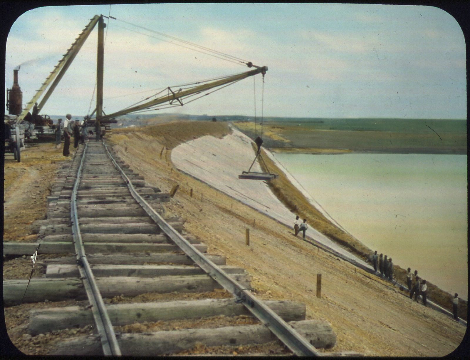
Steam shovels filled small rail cars on narrow-gauge track, up to 500 carloads a day, and horse teams spread the dirt in 6-inch layers. The local gumbo, a clay that caked on the steam rollers, had to be packed by heavy traction engines with widened wheels. The closest stone, a poor sandstone, lay 32 miles off, so concrete slabs paved the upstream face.
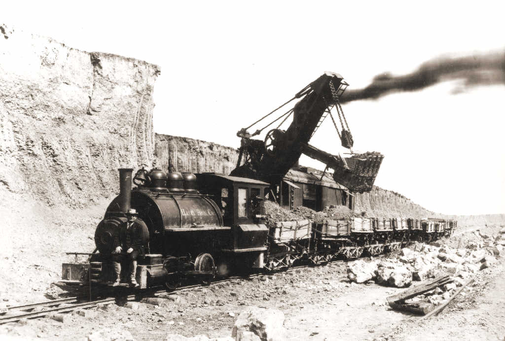
Belle Fourche Dam was finished on June 30, 1911, for about $1.3 million, according to the National Park Service. It runs 6,262 feet and stands 122 feet high, and it was then the largest rolled-earth dam in the world.
Wave action damaged the slabs, and some shifted out of place nearly every year. In 1931, during a drought drawdown, a section of the dam's upstream face slumped, and as many as 366 slabs came loose at once. In 1939 the lower slabs were buried under a rock-faced earth berm, built largely by enrollees of the Civilian Conservation Corps from a camp at the dam's foot, the Park Service says. A second berm and a new spillway followed in 1976 and 1977.
Who Farmed the Project, and How Did They Do?
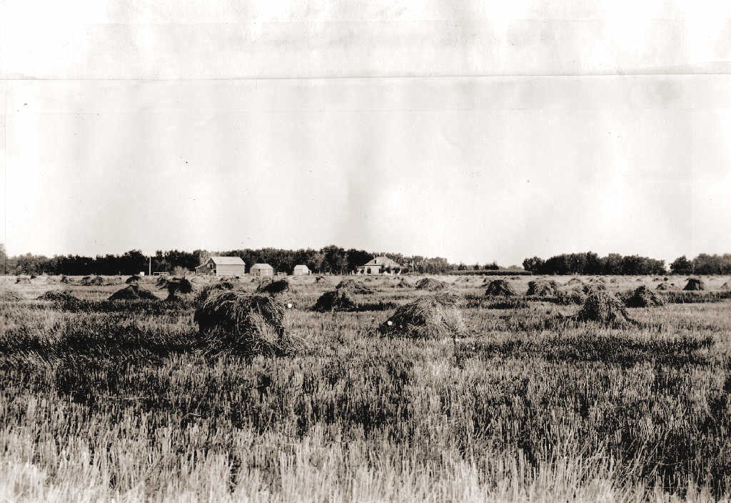
The first unit opened to settlement in June 1907, and in 1908 water reached about 12,000 acres. Many early settlers had never farmed. The Park Service says some former Black Hills miners did well, but many newcomers were lawyers, doctors and clerks new to the work, and some treated it as a hobby. Speculators bought land and let it sit. A project farm also came with its portion of the cost of the dam and canals, and in the farm slump of the 1920s some would-be settlers could not afford one, while several farms on the project were abandoned.
Soil set limits too. The Reclamation Service's planners had described two soils, one sandy, the other a clay loam that locals called gumbo. Most land north of the river is gumbo, which stays wet long after watering; the sandy ground to the south takes a lot of water and suited sugar beets, the Park Service says. Settlers new to irrigation put on too much water: 1,500 acres could no longer be irrigated by 1914, and by 1921 waterlogging had left 4,000 acres in need of drains.
Repayment went badly. A federal review written around 1950, with figures through 1948, put the construction cost at $5,315,000, all meant to be repaid by the water users, and called the original Reclamation Act's 10-year repayment period "optimistically low." Water users were relieved of $1,417,000, about 27 percent; they had repaid $1,187,000 and still owed $2,711,000. The review blamed the drop from about 100,000 planned acres to 55,700 irrigable ones on inexperience in judging which soils could be irrigated and on runoff records too poor to show how much water the river would dependably supply.
Landowners organized the Belle Fourche Irrigation District in 1923, and in 1949 Reclamation turned operation and maintenance over to it. The repayment contract was extended in 1949 and redone in 1976 and 1984 as improvements added to the bill, and in 1990 the district still owed $1,513,000, its manager told Martin J. Jackley in 1994 for a 1995 South Dakota Law Review comment.
Sugar Beets: Promised in 1904, Processed From 1927
The Reclamation Service's early description of the project expected sugar beets to become a major industry, since tests had rated the soil excellent for them. In 1904 Seth Bullock, then promoting Belle Fourche, predicted a beet factory with a weekly payroll above $25,000, SDPB reports. A 1916 promise from the Great Western Sugar Company of a factory, if growers signed up 8,000 acres, fell through when the United States entered World War I, so the valley's beets went by rail to Nebraska.
The Utah-Idaho Sugar Company built a factory at Belle Fourche, dedicated on October 15, 1927. By SDPB's account it began losing money around 1950, and its last run of beets ended on January 12, 1965.
Most of the irrigated land went to hay and grain: about 54,000 acres changed from grazing land to those crops, the dam's 1976 National Register nomination says. That nomination, prepared by a Bureau of Reclamation employee, also put crop value through 1974 above $111.5 million and credited irrigation with a steadier economy than dryland farming had, especially in the Dust Bowl. The federal review counted $32 million in crops from 1912 through 1946, more than six times the federal cost. Both are gross figures, the harvest's worth before farmers paid their own costs, so neither shows which farms made money; the review itself conceded the project had fallen short of its planners' hopes for irrigated land and repayment.
Newell and the Farms the Project Waters Now
The project's headquarters town, Newell, was built on government land and named for Frederick Haynes Newell, the Reclamation Service's chief engineer in 1904. Along the canals, the project built 11 houses for ditch riders, the workers who patrolled the ditches and metered out water; one, built in 1916 east of Nisland, is on the National Register of Historic Places.
Upriver, Belle Fourche was a railroad cattle-shipping town before the project began; that story is on Rails, Cattle and Belle Fourche.
The project irrigates about 57,000 acres. The United States still owns the works, and the irrigation district, based in Newell, runs them. A 1983 act of Congress made them the Belle Fourche Unit of the Pick-Sloan Missouri Basin Program and funded their rehabilitation, which the district dates, with the new name, to 1985. In 2020 the district counted 57,183 irrigable acres and more than 500 farmers, growing mostly alfalfa, corn, soybeans, millet and grass hay. The system has 66 miles of main canals, 450 miles of laterals and 232 miles of open drains, the district reported in 2022.
Water is still the limit. In 2024 the district put the reservoir at 143,306 acre-feet, short of the 172,800 it counts as full, and said it sometimes fails to fill. Its main effort now is putting open, seeping laterals into pipe one stretch at a time, saving an estimated 350 to 490 acre-feet a year per project.
Full, Belle Fourche Reservoir covers about 8,000 acres, with a state recreation area, Rocky Point, on its shore; the reservoir as a lake is on Lakes of the Black Hills.
Piping carries a cost of its own. In 2002 the irrigation district was found eligible for the National Register as a historic district, significant for 1904 to 1949. Under the rule set with the state's historic preservation office that year, a lateral keeps its historic integrity only while at least half its length still runs in its original course, out of pipe, and at least half its old structures survive.
Connected
- Newell, South DakotaThe project's headquarters town, laid out on government land.
- Belle Fourche, South DakotaThe town at the head of the project, near the diversion dam.
- Rails, Cattle and Belle FourcheHow the railroad and the cattle trade made Belle Fourche a shipping town.
- Lakes of the Black HillsBelle Fourche Reservoir as a place to fish, boat and camp.
- Homesteading the Edges of the HillsThe dryland claims around the irrigated valley.
- The National Forest and the CCCThe New Deal corps whose men helped shore up Orman Dam in 1939.
- The 1876 War and the Taking of the HillsHow the 1877 Act took the Hills and the land around them.
Sources
- Exerpts from the early development of the Belle Fourche Project. Bureau of Reclamation, Missouri Basin Region, 2020.
- 1903 letter to the Secretary of the Interior (petition of Butte County residents, April 1903). Bureau of Reclamation, 2015.
- Reclamation Service Letter (report to F. H. Newell, April 29, 1904). Bureau of Reclamation, 2015.
- The Belle Fourche Project (excerpt from the Reclamation Service feasibility report). Bureau of Reclamation, 2015.
- South Dakota: Belle Fourche Dam. National Park Service, 2017.
- Orman Dam (Belle Fourche Dam): National Register of Historic Places Inventory–Nomination Form, prepared by Raymond A. Ninke, Bureau of Reclamation. National Park Service, 1976.
- Belle Fourche Dam (historic civil engineering landmark). American Society of Civil Engineers.
- "Belle Fourche project, South Dakota" (page 394, OCR text; figures through 1948 and 1949), apparently from Water Resources Law, volume 3 of the Report of the President's Water Resources Policy Commission, 1950. Western Waters Digital Library, J. Willard Marriott Library, University of Utah.
- Reclamation Law and the Belle Fourche Irrigation District: A Desperate Fight for a Way of Life in Times of Change, by Martin J. Jackley. South Dakota Law Review 40, 1995 (National Agricultural Law Center reprint).
- The Belle Fourche Sugar Plant, by Brian Gevik. SDPB, 2016.
- Jensen Spur Lateral (WaterSMART grant application). Belle Fourche Irrigation District, published by the Bureau of Reclamation, 2020.
- Meade Lateral Pipeline (WaterSMART grant application). Belle Fourche Irrigation District, published by the Bureau of Reclamation, 2022.
- Anderson Lateral Pipeline (WaterSMART grant application). Belle Fourche Irrigation District, published by the Bureau of Reclamation, 2024.
- Belle Fourche Reservoir Resource Management Plan. Bureau of Reclamation, Dakotas Area Office, 2020.
- Belle Fourche Project (project details and history). Bureau of Reclamation.
- FY 2026 Program/Project Authorities List (Belle Fourche Unit: Public Law 98-157, November 17, 1983). Bureau of Reclamation, fiscal year 2026 budget.
- South Dakota (National Register properties). Bureau of Reclamation, Cultural Resources, 2015.
- Rocky Point Recreation Area. South Dakota Game, Fish and Parks.
- Fort Laramie Treaty, 1868. The Avalon Project, Yale Law School.
- Agreement with the Sioux, Arapaho and Northern Cheyenne, 1876, in Kappler, Indian Affairs: Laws and Treaties. Oklahoma State University Libraries.
Last reviewed: